Granite Domes of Yosemite National Park facts for kids
Many granite domes are in Yosemite National Park.
Explanation of the concept of "clean prominence"
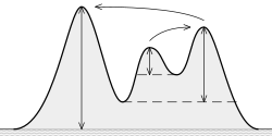
First a note about topographic prominence, which will lead to "clean prominence":
In short: At a col, use the col's highest contour line, and pick the lowest contour line that can draw a closed contour about the dome.
We start by computing the "clean prominence" of a dome. The vertical distance from
- the top of the dome to
- the lowest col from which a contour line [1][2][3][4][5] circles the top of the dome
is the clean prominence. To calculate this, you need to know
- the elevation of the top of the dome and
- the elevation of the lowest col, from which a contour line encircles the top of the dome

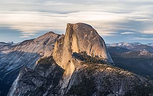
Yosemite has many granite domes, among them Half Dome.
Here we use "clean prominence."
The list of granite domes
If a dome needs added, feel free to add it. A few are listed in the region of "Tuolumne Meadows/Lake Tenaya," as they fell rough midway between. Also, no references are given direct right of elevation and prominence — they are further right, under Web reference(s).
A list, divided in a sortable table:
| Name of Dome | Summit Elevation | Clean prominence | County | Region of Yosemite | Web reference(s) |
|---|---|---|---|---|---|
| Basket Dome | 2,320 metres (7,610 ft) | 64 metres (210 ft) | Mariposa County | Yosemite Valley | [6] |
| Daff Dome | 2,790 metres (9,150 ft) | 157 metres (515 ft) | Tuolumne County | Tuolumne Meadows | [7][8] |
| Doda Dome | 2,715 metres (8,907 ft) | 82 metres (269 ft) | Tuolumne County | Tuolumne Meadows | [9][10] |
| Dog Dome | 2,865 metres (9,400 ft) | 24 metres (79 ft) | Tuolumne County | Tuolumne Meadows | [11] |
| Dozier Dome | 2,847 metres (9,341 ft) | 12 metres (39 ft) | Mariposa County | Lake Tenaya | [12][13] |
| Drug Dome | 2,769 metres (9,085 ft) | 0 metres (0 ft) | Mariposa County | Tuolumne Meadows | [14][15] |
| East Cottage Dome, also, "Erratic Dome" | 2,780 metres (9,120 ft) | 61 metres (200 ft) | Tuolumne County | Tuolumne Meadows | [16] |
| East Quarter Dome | 2,535 metres (8,317 ft) | 36 metres (118 ft) | Mariposa County | Yosemite Valley | [17] |
| Fairview Dome | 2,964 metres (9,724 ft) | 184 metres (604 ft) | Tuolumne County | Tuolumne Meadows | [18][19] |
| Half Dome | 2,694 metres (8,839 ft) | 415 metres (1,362 ft) | Mariposa County | Yosemite Valley/Little Yosemite Valley | [20][21][22] |
| Hammer Dome | 2,665 metres (8,743 ft) | 56 metres (184 ft) | Tuolumne County | Tuolumne Meadows | [23] |
| Harlequin Dome | 2,710 metres (8,890 ft) | Mariposa County | Lake Tenaya | [24] | |
| Hetch Hetchy Dome | 1,889 metres (6,198 ft) | 72 metres (236 ft) | Tuolumne County | Hetch Hetchy | [25] |
| Kolana Rock | 1,759 metres (5,771 ft) | 192 metres (630 ft) | Mariposa County | Hetch Hetchy | [26] |
| Lamb Dome | 2,806 metres (9,206 ft) | 117 metres (384 ft) | Tuolumne County | Tuolumne Meadows/Lake Tenaya | [27][28] |
| Lembert Dome | 2,880 metres (9,450 ft) | 88 metres (289 ft) | Tuolumne County | Tuolumne Meadows | [29][30] |
| Liberty Cap | 2,157 feet (657 m) | 304 metres (997 ft) | Mariposa County | Little Yosemite Valley | [31][32] |
| Mariolumne Dome | 3,039 metres (9,970 ft) | 143 metres (469 ft) | Tuolumne County | Tuolumne Meadows/Lake Tenaya | [33][34] |
| Marmot Dome | 2,829 metres (9,281 ft) | 13 metres (43 ft) | Tuolumne County | Tuolumne Meadows | [35][36] |
| Medlicott Dome | 3,011 metres (9,879 ft) | 61 metres (200 ft) | Mariposa County/Tuolumne County | Tuolumne Meadows/Lake Tenaya | [37][38] |
| Moraine Dome | 2,440 metres (8,010 ft) | 60 metres (200 ft) | Mariposa County | Little Yosemite Valley | [39] |
| North Dome | 2,299 metres (7,543 ft) | 43 metres (141 ft) | Mariposa County | Yosemite Valley | [40][41] |
| North Whizz Dome | 2,707 metres (8,881 ft) | 37 metres (121 ft) | Tuolumne County | Tuolumne Meadows/Lake Tenaya | [42] |
| Polly Dome | 2,989 metres (9,806 ft) | 331 metres (1,086 ft) | Mariposa County | Lake Tenaya | [43] |
| Pothole Dome | 2,670 metres (8,760 ft) | 12 metres (39 ft) | Tuolumne County | Tuolumne Meadows | [44][45] |
| Puppy Dome | 2,670 metres (8,760 ft) | 24 metres (79 ft) | Tuolumne County | Tuolumne Meadows | [46][47] |
| Pywiack Dome | 2,698 metres (8,852 ft) | 77 metres (253 ft) | Mariposa County | Lake Tenaya | [48][49] |
| SAR Dome | 2,691 metres (8,829 ft) | 76 metres (249 ft) | Tuolumne County | Glen Aulin High Sierra Camp | [50] |
| Scar Dome | 2,697 metres (8,848 ft) | 27 metres (89 ft) | Tuolumne County | Glen Aulin High Sierra Camp | [51] |
| Scary Dome | 2,684 metres (8,806 ft) | 26 metres (85 ft) | Tuolumne County | Glen Aulin High Sierra Camp | [52] |
| Sentinel Dome | 2,476 metres (8,123 ft) | 99 metres (325 ft) | Mariposa County | Glacier Point | [53][54] |
| South Whizz Dome | 2,707 metres (8,881 ft) | 25 metres (82 ft) | Tuolumne County | Tuolumne Meadows | [55] |
| Stately Pleasure Dome | 2,755 metres (9,039 ft) | 0 metres (0 ft) | Mariposa County | Lake Tenaya | [56][57] |
| Sugarloaf Dome | 2,342 metres (7,684 ft) | 99 metres (325 ft) | Mariposa County | Little Yosemite Valley | [58] |
| Turtleback Dome | 1,615 metres (5,299 ft) | 6 metres (20 ft) | Mariposa County | Wildcat Falls | [59] |
| V-Tree Dome | 2,559 metres (8,396 ft) | 47 metres (154 ft) | Tuolumne County | Grand Canyon of the Tuolumne | [60] |
| Wawona Dome | 2,102 metres (6,896 ft) | 17 metres (56 ft) | Mariposa County | Chilnualna Falls | [61] |
| West Cottage Dome | 2,755 metres (9,039 ft) | 12 metres (39 ft) | Tuolumne County | Tuolumne Meadows | [62] |
| West Quarter Dome | 2,487 metres (8,159 ft) | 12 metres (39 ft) | Mariposa County | Little Yosemite Valley | [63] |

All content from Kiddle encyclopedia articles (including the article images and facts) can be freely used under Attribution-ShareAlike license, unless stated otherwise. Cite this article:
Granite Domes of Yosemite National Park Facts for Kids. Kiddle Encyclopedia.

