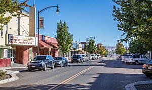
Grandview, Washington facts for kids
Quick facts for kids
Grandview, Washington
|
|
|---|---|

Division St.
|
|

Location of Grandview, Washington
|
|
| Country | United States |
| State | Washington |
| County | Yakima |
| Incorporated | September 21, 1909 |
| Government | |
| • Type | Mayor–council |
| Area | |
| • Total | 6.52 sq mi (16.89 km2) |
| • Land | 6.44 sq mi (16.68 km2) |
| • Water | 0.08 sq mi (0.21 km2) |
| Elevation | 804 ft (245 m) |
| Population
(2020)
|
|
| • Total | 10,907 |
| • Estimate
(2022)
|
11,043 |
| • Density | 1,720.19/sq mi (664.17/km2) |
| Time zone | UTC−8 (Pacific (PST)) |
| • Summer (DST) | UTC−7 (PDT) |
| ZIP code |
98930
|
| Area code(s) | 509 |
| FIPS code | 53-27925 |
| GNIS feature ID | 1512251 |
Grandview is a city in Yakima County, Washington, United States. It is about 38 miles west of Kennewick and 38 miles southeast of Yakima. The population was 10,907 at the 2020 census. Grandview's economy is agriculture based; with apples, cherries, concord and wine grapes, hops, asparagus, corn, wheat, dairy and other fruit and vegetable production supported by processing plants and cold storage facilities.
History
Grandview received its name from the Granger Land Company in 1905 due to its view of Mount Rainier and Mount Adams. Grandview was officially incorporated on September 21, 1909. It began simply as the halfway point on the rail line between Prosser and Sunnyside.
Geography
Grandview is located at 46°15′13″N 119°54′36″W / 46.25361°N 119.91000°W (46.253670, -119.910133).
According to the United States Census Bureau, the city has a total area of 6.31 square miles (16.34 km2), of which, 6.23 square miles (16.14 km2) is land and 0.08 square miles (0.21 km2) is water.
Demographics
| Historical population | |||
|---|---|---|---|
| Census | Pop. | %± | |
| 1910 | 320 | — | |
| 1920 | 1,011 | 215.9% | |
| 1930 | 1,085 | 7.3% | |
| 1940 | 1,449 | 33.5% | |
| 1950 | 2,503 | 72.7% | |
| 1960 | 3,366 | 34.5% | |
| 1970 | 3,605 | 7.1% | |
| 1980 | 5,615 | 55.8% | |
| 1990 | 7,169 | 27.7% | |
| 2000 | 8,377 | 16.9% | |
| 2010 | 10,862 | 29.7% | |
| 2020 | 10,907 | 0.4% | |
| 2022 (est.) | 11,043 | 1.7% | |
| U.S. Decennial Census 2020 Census |
|||
2010 census
As of the 2010 census, there were 10,862 people, 2,996 households, and 2,459 families living in the city. The population density was 1,743.5 inhabitants per square mile (673.2/km2). There were 3,136 housing units at an average density of 503.4 per square mile (194.4/km2). The racial makeup of the city was 55.2% White, 0.9% African American, 0.6% Native American, 0.5% Asian, 0.1% Pacific Islander, 38.8% from other races, and 4.0% from two or more races. Hispanic or Latino of any race were 79.7% of the population.
There were 2,996 households, of which 57.1% had children under the age of 18 living with them, 54.5% were married couples living together, 18.5% had a female householder with no husband present, 9.0% had a male householder with no wife present, and 17.9% were non-families. 14.2% of all households were made up of individuals, and 5.6% had someone living alone who was 65 years of age or older. The average household size was 3.60 and the average family size was 3.90.
The median age in the city was 26.3 years. 37% of residents were under the age of 18; 11.2% were between the ages of 18 and 24; 26.8% were from 25 to 44; 17.1% were from 45 to 64; and 7.9% were 65 years of age or older. The gender makeup of the city was 50.0% male and 50.0% female.
Notable people
- Lorena González, Seattle city councilmember
- Gloria Mendoza, mayor of Grandview
- Margaret Rayburn, educator and member of the Washington House of Representatives
- Janet Waldo, voice-over actress
Major highways
See also
 In Spanish: Grandview (Washington) para niños

