Grand Staircase–Escalante National Monument facts for kids
Quick facts for kids Grand Staircase–Escalante National Monument |
|
|---|---|
|
IUCN Category V (Protected Landscape/Seascape)
|
|
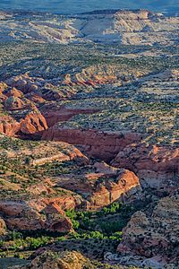
A canyon in Grand Staircase–Escalante National Monument
|
|
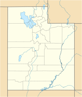
| Location | Kane County and Garfield County, Utah, United States |
| Nearest city | Kanab, Utah |
| Area | 1,003,863 acres (4,062.49 km2) |
| Established | September 18, 1996 |
| Visitors | 878,000 (in 2014) |
| Governing body | Bureau of Land Management |
| Website | Grand Staircase–Escalante National Monument |
The Grand Staircase–Escalante National Monument (GSENM) is a United States national monument originally designated in 1996 as 1,880,461 acres (7,610 km2) of protected land in southern Utah. In 2017, the monument's size was reduced by half in a succeeding presidential proclamation. The land is among the most remote in the country; it was the last to be mapped in the contiguous United States.
There are three main regions: the Grand Staircase, the Kaiparowits Plateau, and the Canyons of the Escalante (Escalante River). All regions are administered by the Bureau of Land Management (BLM) as part of the National Conservation Lands system. President Bill Clinton designated the area as a national monument in 1996 using his authority under the Antiquities Act. Grand Staircase–Escalante is the largest national monument managed by the BLM.
Management
The monument is managed by the Bureau of Land Management (BLM) rather than the National Park Service. This was the first U.S. national monument managed by the BLM. Visitor centers are located in Cannonville, Big Water, Escalante, and Kanab.
Geography
The monument stretches from the towns of Big Water, Glendale, and Kanab, Utah in the southwest, to the towns of Escalante and Boulder in the northeast. Originally encompassing 1,880,461 acres (7,610 km2), the monument was slightly larger in area than the state of Delaware. After a reduction ordered by presidential proclamation in December 2017, the monument now encompasses 1,003,863 acres (4,062 km2).
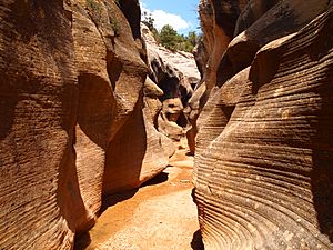
The western part of the monument is dominated by the Paunsaugunt Plateau and the Paria River, and is adjacent to Bryce Canyon National Park. This section shows the geologic progression of the Grand Staircase. Features include the slot canyons of Bull Valley Gorge, Willis Creek, and Lick Wash which are accessed from Skutumpah Road.
The center section is dominated by a single long ridge, called the Kaiparowits Plateau from the west, and Fifty-Mile Mountain when viewed from the east. Fifty-Mile Mountain stretches southeast from the town of Escalante to the Colorado River in Glen Canyon. The eastern face of the mountain is a 2,200 ft (670 m) escarpment. The western side (the Kaiparowits Plateau) is a shallow slope descending to the south and west.
East of Fifty-Mile Mountain are the Canyons of the Escalante. The monument is bounded by Glen Canyon National Recreation Area on the east and south. The popular hiking, backpacking and canyoneering areas include Calf Creek Falls off Utah Scenic Byway 12, and Zebra Canyon, Harris Wash, and the Devils Garden. The latter areas are accessed via the Hole-in-the-Rock Road which extends southeast from Escalante, near the base of Fifty-Mile Mountain. The Dry Fork Slots of Coyote Gulch and lower Coyote Gulch are also located off the Hole-in-the-Rock Road; however, since December 2017, they are no longer within monument boundaries (see map).
Paleontology
Since 2000, numerous dinosaur fossils over 75 million years old have been found at Grand Staircase–Escalante.
In 2002, a volunteer at the monument discovered a 75-million-year-old dinosaur near the Arizona border. On October 3, 2007, the dinosaur's name, Gryposaurus monumentensis (hook-beaked lizard from the monument) was announced in the Zoological Journal of the Linnean Society. G. monumentensis was at least 30 feet (9.1 m) long and 10 feet (3.0 m) tall, and has a powerful jaw with more than 800 teeth. Many of the specimens from the Kaiparowits Formation are reposited at the Natural History Museum of Utah in Salt Lake City.
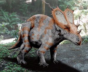
Two ceratopsid (horned) dinosaurs, also discovered at the monument, were introduced by the Utah Geological Survey in 2007. They were uncovered in the Wahweap formation, which is just below the Kaiparowits formation where the duckbill was extracted. They lived about 80 million or 81 million years ago. The two fossils are called the Last Chance skull and the Nipple Butte skull. They were found in 2002 and 2001, respectively. Both were later identified as belonging to Diabloceratops.
In 2013 the discovery of a new species, Lythronax argestes, was announced. It is a tyrannosaur that is approximately 13 million years older than Tyrannosaurus, named for its great resemblance to its descendant. The specimen can be seen at the Natural History Museum of Utah.
Human history
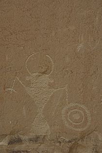
Humans did not settle permanently in the area until the Basketmaker III Era, somewhere around AD 500. Both the Fremont and ancestral Puebloan people lived here; the Fremont hunting and gathering below the plateau and near the Escalante Valley, and the ancestral Puebloans farming in the canyons. Both groups grew corn, beans, and squash, and built brush-roofed pithouses and took advantage of natural rock shelters. Ruins and rock art can be found throughout the monument.
The first record of white settlers in the region dates from 1866, when Captain James Andrus led a group of cavalry to the headwaters of the Escalante River. In 1871 Jacob Hamblin of Kanab, on his way to resupply the second John Wesley Powell expedition, mistook the Escalante River for the Dirty Devil River and became the first Anglo to travel the length of the canyon.
In 1879 the San Juan Expedition crossed through the monument on their way to a proposed Mormon colony in the far southeastern corner of Utah. Traveling on a largely unexplored route, the group eventually arrived at the 1200-foot (400 m) sandstone cliffs that surrounded Glen Canyon. They found the only breach for many miles in the otherwise vertical cliffs, which they named Hole-in-the-Rock. The narrow, steep, and rocky crevice eventually led to a steep sandy slope in the lower section and eventually down to the Colorado River. With winter settling in, the company decided to go down the crevice, rather than retreat. After six weeks of labor, including excavation and the use of explosives to shift rock, they rigged a pulley system to lower their wagons and animals down the resulting road and off the cliff. There they built a ferry, crossed the river and climbed back out through Cottonwood Canyon on the other side.
Images for kids
-
Metate Arch in Devils Garden
See also
 In Spanish: Monumento nacional de Grand Staircase-Escalante para niños


