Gore District, New Zealand facts for kids
Quick facts for kids
Gore District
|
|
|---|---|
|
Territorial authority district
|
|

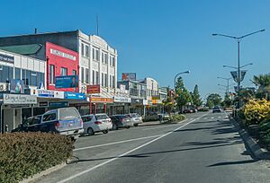
Main Street in Gore
|
|

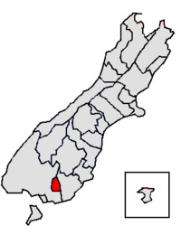
Location of the Gore District within the South Island
|
|
| Country | New Zealand |
| Region | Southland |
| Wards |
|
| Formed | 1989 |
| Seat | Gore |
| Area | |
| • Total | 1,253.85 km2 (484.11 sq mi) |
| Population
(June 2023)
|
|
| • Total | 13,050 |
| • Density | 10.408/km2 (26.956/sq mi) |
| Time zone | UTC+12 (NZST) |
| • Summer (DST) | UTC+13 (NZDT) |
| Postcode(s) |
Map of postcodes
|
Gore District is a district in the Southland Region of the South Island of New Zealand. It is named for Gore, the district's biggest township.
Geography
The Gore District is located in the south of the South Island. The two neighbouring districts are Southland in the west and Clutha in the east. The district has a land area of 1,253.85 square kilometres (484.11 sq mi). The seat of the district council is in the town of Gore. The district has a population of 13,050 (June 2023)
Towns and localities
Gore is the main centre of Gore District. Other places in the district include the following, based on wards:
Gore Ward:
- Gore (seat)
Kaiwera-Waimumu Ward:
- Kaiwera Community Board:
- Diamond Peak
- East Gore
- Ferndale
- Kaiwera
- Otaraia
- Tuturau (north part)
- Waikana
- Watarikiki (east part)
- Waimumu Community Board:
- Brydone (north part)
- Charlton
- Croydon
- Croydon Bush
- Otamita
- Te Tipua (north part)
- Upper Charlton
- Waimumu
- Waitane (east part)
Mataura Ward:
Waikaka Ward:
- Arthurton
- Benio
- Chatton
- Chatton North
- East Chatton
- Greenvale
- Knapdale
- Maitland
- Mandeville (south part)
- Merino Downs (west part)
- McNab
- Otama
- Otikerama
- Pukerau
- Te Kiteroa (west part)
- Waikaka
- Waikaka Valley
- Wendon (east part)
- Wendon Valley
- Whiterigg
- Willowbank
Demographics
Gore District covers 1,253.85 km2 (484.11 sq mi) and had an estimated population of 13,050 as of June 2023, with a population density of 10 people per km2.
| Historical population | ||
|---|---|---|
| Year | Pop. | ±% p.a. |
| 2006 | 12,108 | — |
| 2013 | 12,033 | −0.09% |
| 2018 | 12,396 | +0.60% |
| 2023 | 12,711 | +0.50% |
| Ethnicity | Population |
|---|---|
| New Zealand European |
11,040
|
| Māori |
1,953
|
| Pasifika |
273
|
| Asian |
504
|
| MELAA |
48
|
| Other |
216
|
Gore District had a population of 12,711 in the 2023 New Zealand census, an increase of 315 people (2.5%) since the 2018 census, and an increase of 678 people (5.6%) since the 2013 census. There were 5,814 dwellings. The median age was 42.8 years (compared with 38.1 years nationally). There were 2,304 people (18.1%) aged under 15 years, 2,148 (16.9%) aged 15 to 29, 5,541 (43.6%) aged 30 to 64, and 2,721 (21.4%) aged 65 or older.
Ethnicities were 86.9% European/Pākehā, 15.4% Māori, 2.1% Pasifika, 4.0% Asian, 0.4% Middle Eastern, Latin American and African New Zealanders, and 1.7% other. People may identify with more than one ethnicity.
Gore District had a population of 12,396 at the 2018 New Zealand census. There were 5,076 households, comprising 6,153 males and 6,246 females, giving a sex ratio of 0.99 males per female.
The percentage of people born overseas was 8.8, compared with 27.1% nationally.
Although some people chose not to answer the census's question about religious affiliation, 47.2% had no religion, 43.2% were Christian, 0.6% had Māori religious beliefs, 0.4% were Hindu, 0.3% were Muslim, 0.1% were Buddhist and 1.0% had other religions.
Of those at least 15 years old, 1,008 (10.1%) people had a bachelor's or higher degree, and 2,883 (28.8%) people had no formal qualifications. The median income was $30,900, compared with $31,800 nationally. 1,197 people (11.9%) earned over $70,000 compared to 17.2% nationally. The employment status of those at least 15 was that 5,121 (51.1%) people were employed full-time, 1,539 (15.4%) were part-time, and 261 (2.6%) were unemployed.
| Name | Area (km2) | Population | Density (per km2) | Households | Median age | Median income |
|---|---|---|---|---|---|---|
| Waikaka Ward | 587.00 | 1,560 | 2.7 | 582 | 39.0 years | $41,400 |
| Kaiwera-Waimumu Ward | 651.22 | 1,689 | 2.6 | 600 | 45.5 years | $38,200 |
| Gore Ward | 10.28 | 7,518 | 731.3 | 3,234 | 44.8 years | $28,900 |
| Mataura Ward | 5.33 | 1,629 | 305.6 | 660 | 39.6 years | $26,600 |
| New Zealand | 37.4 years | $31,800 |
History
The European history of Gore started in 1855 with the arrival of Scottish settlers. After the town site was surveyed, the provincial superintendent, James Alexander Robertson Menzies, named the site for his friend, the Governor of New Zealand, Thomas Gore Browne. The original name of the township, Long Ford or Longford, remained for some time, but when the railway reached the town, the shorter name became common and was also applied to the wider district. The township of Gore was incorporated and became a borough council in 1885.
In the local government reform in 1989, the Gore and Mataura borough councils and parts of Southland County Council were amalgamated to form Gore District.
Governance
The district council is headed by a mayor who is elected at large and complemented by eleven councillors from various wards. Five councillors represent the Gore ward, one councillor each represents the Mataura, Kaiwera-Waimumu, and Waikaka wards, and there is one further district-wide ward that is represented by three councillors. The current mayor, Ben Bell, was elected in the 2022 New Zealand local elections as Gore's youngest mayor at the age of 23 years, defeating the incumbent Tracy Hicks.
Current body
As of 2022, the current council members are:
- Mayor Ben Bell
- Gore ward: Bronwyn Reid, Bret Highsted, Nick Grant, Glenys Dickson, Doug Grant
- Mataura ward: Neville Phillips
- Waikaka ward: John Gardyne
- Waimumu-Kaiwera ward: Stewart MacDonell
- Councillors elected at-large: Cliff Bolger, Nicky Davis, Richard McPhail


