Golden Glades, Florida facts for kids
Quick facts for kids
Golden Glades, Florida
|
|
|---|---|

Location in Miami-Dade County and the state of Florida
|
|

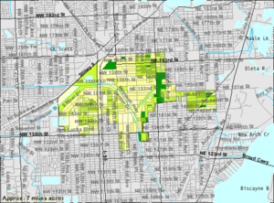
U.S. Census Bureau map showing CDP boundaries
|
|
| Country | |
| State | |
| County | |
| Area | |
| • Total | 5.02 sq mi (13.01 km2) |
| • Land | 4.83 sq mi (12.51 km2) |
| • Water | 0.19 sq mi (0.50 km2) |
| Elevation | 3 ft (1 m) |
| Highest elevation | 15 ft (5 m) |
| Population
(2020)
|
|
| • Total | 32,499 |
| • Density | 6,725.8/sq mi (2,596.8/km2) |
| Time zone | UTC-5 (Eastern (EST)) |
| • Summer (DST) | UTC-4 (EDT) |
| ZIP Codes | |
| Area code(s) | 305, 786, 645 |
| FIPS code | 12-26375 |
| GNIS feature ID | 1867145 |
Biscayne Gardens is a census-designated place (CDP) in Miami-Dade County, Florida, United States. It is part of the Miami metropolitan area of South Florida. The population was 32,499 at the 2020 US census.
It's also the location of the Biscayne Gardens Interchange which connects the Florida Turnpike, Interstate 95, US 441, State Road 9, and the Palmetto Expressway.
Geography
Biscayne Gardens is located in northeastern Miami-Dade County at 25°54′46″N 80°11′52″W / 25.91278°N 80.19778°W (25.912771, -80.197688). It is 11 miles (18 km) north of downtown Miami. The community is bordered by four cities: Miami Gardens to the northwest, North Miami Beach to the northeast, North Miami to the southeast and south, and Opa-locka to the west.
According to the United States Census Bureau, the CDP has a total area of 5.0 square miles (13 km2). 4.8 square miles (12 km2) of it are land and 0.2 square miles (0.5 km2) (3.82%) are water.
The Golden Glades Interchange is on the northern side of the community. From it, Interstate 95 leads south 11 miles (18 km) to the center of Miami and north-northeast 15 miles (24 km) to Fort Lauderdale, Florida's Turnpike leads north parallel to and inland from I-95, and the Palmetto Expressway leads west and south 23 miles (37 km) to U.S. Route 1 in Pinecrest. From the same interchange, State Road 9, a surface road, leads southwest 3 miles (5 km) to the center of Opa-locka, and U.S. 441 leads south parallel to I-95 as far as downtown Miami.
Demographics
| Historical population | |||
|---|---|---|---|
| Census | Pop. | %± | |
| 1980 | 23,154 | — | |
| 1990 | 25,474 | 10.0% | |
| 2000 | 32,623 | 28.1% | |
| 2010 | 33,145 | 1.6% | |
| 2020 | 32,499 | −1.9% | |
| U.S. Decennial Census 2010 2020 |
|||
2010 and 2020 census
| Race / Ethnicity (NH = Non-Hispanic) | Pop 2010 | Pop 2020 | % 2010 | % 2020 |
|---|---|---|---|---|
| White (NH) | 2,334 | 1,676 | 7.04% | 5.16% |
| Black or African American (NH) | 23,358 | 22,201 | 70.47% | 68.31% |
| Native American or Alaska Native (NH) | 46 | 37 | 0.14% | 0.11% |
| Asian (NH) | 520 | 519 | 1.57% | 1.60% |
| Pacific Islander or Native Hawaiian (NH) | 15 | 13 | 0.05% | 0.04% |
| Some other race (NH) | 82 | 175 | 0.25% | 0.54% |
| Mixed race or Multiracial (NH) | 656 | 643 | 1.98% | 1.98% |
| Hispanic or Latino (any race) | 6,134 | 7,235 | 18.51% | 22.26% |
| Total | 33,145 | 32,499 | 100.00% | 100.00% |
As of the 2020 United States census, there were 32,499 people, 10,072 households, and 6,892 families residing in the CDP.
As of the 2010 United States census, there were 33,145 people, 9,320 households, and 6,992 families residing in the CDP.
Education
Biscayne Gardens is within the Miami-Dade County Public Schools.
Transportation
Biscayne Gardens is served by Tri-Rail at the Golden Glades station. It contains a park-and-ride facility, and also serves as a feeder for buses from the surrounding area, run by both Miami-Dade Transit and Broward County Transit.
See also
 In Spanish: Golden Glades para niños

