Glascock County, Georgia facts for kids
Quick facts for kids
Glascock County
|
|
|---|---|

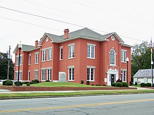
Glascock County Courthouse in Gibson
|
|

Location within the U.S. state of Georgia
|
|
 Georgia's location within the U.S. |
|
| Country | |
| State | |
| Founded | 1857 |
| Named for | Thomas Glascock |
| Seat | Gibson |
| Largest city | Gibson |
| Area | |
| • Total | 144 sq mi (370 km2) |
| • Land | 144 sq mi (370 km2) |
| • Water | 0.7 sq mi (2 km2) 0.5%% |
| Population
(2020)
|
|
| • Total | 2,884 |
| • Density | 20/sq mi (8/km2) |
| Time zone | UTC−5 (Eastern) |
| • Summer (DST) | UTC−4 (EDT) |
| Congressional district | 12th |
Glascock County is a county located in the U.S. state of Georgia. As of the 2020 census, the population was 2,884, making it the fourth-least populous county in Georgia. The county seat is Gibson. The county was created on December 19, 1857.
Contents
History
The county is named after Thomas Glascock, a soldier in the War of 1812, general in the First Seminole War and U.S. representative.
Geography
According to the U.S. Census Bureau, the county has a total area of 144 square miles (370 km2), of which 144 square miles (370 km2) is land and 0.7 square miles (1.8 km2) (0.5%) is water. It is the fourth-smallest county in Georgia by area. Behind Clayton, Rockdale County , and Clark counties
The vast majority of Glascock County is located in the Upper Ogeechee River sub-basin of the Ogeechee River basin, with just the very northeastern corner of the county, northeast of State Route 80, located in the Brier Creek sub-basin of the Savannah River basin.
Major highways
Adjacent counties
- Warren County - north
- Jefferson County - southeast
- Hancock County - northwest
- Washington County - southwest
Communities
Cities
Town
Unincorporated communities
- Agricola
- Bastonville
Demographics
| Historical population | |||
|---|---|---|---|
| Census | Pop. | %± | |
| 1860 | 2,437 | — | |
| 1870 | 2,736 | 12.3% | |
| 1880 | 3,577 | 30.7% | |
| 1890 | 3,720 | 4.0% | |
| 1900 | 4,516 | 21.4% | |
| 1910 | 4,669 | 3.4% | |
| 1920 | 4,192 | −10.2% | |
| 1930 | 4,388 | 4.7% | |
| 1940 | 4,547 | 3.6% | |
| 1950 | 3,579 | −21.3% | |
| 1960 | 2,672 | −25.3% | |
| 1970 | 2,280 | −14.7% | |
| 1980 | 2,382 | 4.5% | |
| 1990 | 2,357 | −1.0% | |
| 2000 | 2,556 | 8.4% | |
| 2010 | 3,082 | 20.6% | |
| 2020 | 2,884 | −6.4% | |
| 2023 (est.) | 2,954 | −4.2% | |
| U.S. Decennial Census 1790-1880 1890-1910 1920-1930 1930-1940 1940-1950 1960-1980 1980-2000 2010 |
|||
| Race | Num. | Perc. |
|---|---|---|
| White | 2,573 | 89.22% |
| Black or African American | 196 | 6.8% |
| Asian | 7 | 0.24% |
| Pacific Islander | 2 | 0.07% |
| Other/Mixed | 54 | 1.87% |
| Hispanic or Latino | 52 | 1.8% |
As of the 2020 United States census, there were 2,884 people, 1,108 households, and 726 families residing in the county.
See also
 In Spanish: Condado de Glascock para niños

