Franklin Township, Hunterdon County, New Jersey facts for kids
Quick facts for kids
Franklin Township, New Jersey
|
||
|---|---|---|
|
Township
|
||
|
||
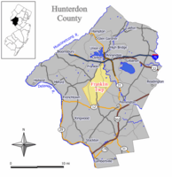
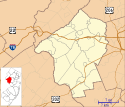
Location of Franklin Township in Hunterdon County highlighted in yellow (right). Inset map: Location of Hunterdon County in New Jersey highlighted in black (left).
|
||
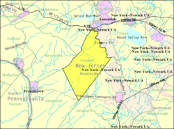
Census Bureau map of Franklin Township, Hunterdon County, New Jersey
|
||
| Country | ||
| State | ||
| County | ||
| Incorporated | April 7, 1845 | |
| Named for | Benjamin Franklin | |
| Government | ||
| • Type | Township | |
| • Body | Township Committee | |
| Area | ||
| • Total | 23.18 sq mi (60.02 km2) | |
| • Land | 23.04 sq mi (59.66 km2) | |
| • Water | 0.14 sq mi (0.36 km2) 0.60% | |
| Area rank | 120th of 565 in state 11th of 26 in county |
|
| Elevation | 600 ft (200 m) | |
| Population
(2020)
|
||
| • Total | 3,267 | |
| • Estimate
(2023)
|
3,286 | |
| • Rank | 436th of 565 in state 16th of 26 in county |
|
| • Density | 141.8/sq mi (54.7/km2) | |
| • Density rank | 524th of 565 in state 22nd of 26 in county |
|
| Time zone | UTC−05:00 (Eastern (EST)) | |
| • Summer (DST) | UTC−04:00 (Eastern (EDT)) | |
| ZIP Code |
08867 – Pittstown, New Jersey
|
|
| Area code(s) | 908 | |
| FIPS code | 3401924870 | |
| GNIS feature ID | 0882184 | |
Franklin Township is a township in central Hunterdon County, in the U.S. state of New Jersey. As of the 2020 United States census, the township's population was 3,267, an increase of 72 (+2.3%) from the 2010 census count of 3,195, which in turn reflected an increase of 205 (+6.9%) from the 2,990 counted in the 2000 census. Most of the township lies on the Hunterdon Plateau with only the eastern section along the South Branch Raritan River being on the lower part of the Newark Basin.
Contents
History
Long populated by the Lenape (Delaware) Native Americans, the first European settlement of present-day Franklin was around 1700, when it became a Quaker community of settlers who came from Burlington County. The most reliable records that are available about the early days of the Township are found in the minutes of the Friends' Meeting in Quakertown.
Franklin Township was established by an act of the New Jersey Legislature on April 7, 1845, when it was created from portions of Kingwood Township, based on the results of a referendum held that day. Portions of the township were taken to form Clinton town on April 5, 1865. The township was named for Benjamin Franklin.
The rich soil made the township a center of agriculture for hundreds of years. While Franklin Township had long hosted a major dairy farming industry, in modern times, the primary crops have been corn, hay and soybeans.
Geography
According to the United States Census Bureau, the township had a total area of 23.18 square miles (60.02 km2), including 23.04 square miles (59.66 km2) of land and 0.14 square miles (0.36 km2) of water (0.60%).
Unincorporated communities, localities and place names located partially or completely within the township include Allens Corner, Alvater Corner, Cherryville (previously known as Dogtown), Grandin, Kingtown, Lansdowne, Littletown, Oak Grove, Pittstown, Quakertown (previously known as Fairview), Sidney and Sunnyside. Pittstown, previously known as Hoffs, is also spread across Alexandria Township and Union Township.
The Capoolong Creek, which runs through Pittstown, was an attraction to early settlers and they soon established three of the oldest churches in present-day Hunterdon: Thomas Episcopal, established in 1723, Bethlehem Presbyterian, organized in 1730 and the Quaker Church in 1733.
The township borders the Hunterdon County municipalities of Alexandria Township, Clinton, Clinton Township, Delaware Township, Kingwood Township, Raritan Township and Union Township.
Demographics
| Historical population | |||
|---|---|---|---|
| Census | Pop. | %± | |
| 1850 | 1,454 | — | |
| 1860 | 1,552 | 6.7% | |
| 1870 | 1,342 | * | −13.5% |
| 1880 | 1,338 | −0.3% | |
| 1890 | 1,287 | −3.8% | |
| 1900 | 1,258 | −2.3% | |
| 1910 | 1,099 | −12.6% | |
| 1920 | 980 | −10.8% | |
| 1930 | 1,100 | 12.2% | |
| 1940 | 1,211 | 10.1% | |
| 1950 | 1,255 | 3.6% | |
| 1960 | 1,777 | 41.6% | |
| 1970 | 2,154 | 21.2% | |
| 1980 | 2,294 | 6.5% | |
| 1990 | 2,851 | 24.3% | |
| 2000 | 2,990 | 4.9% | |
| 2010 | 3,195 | 6.9% | |
| 2020 | 3,267 | 2.3% | |
| 2023 (est.) | 3,286 | 2.8% | |
| Population sources: 1850–1920 1850–1870 1850 1870 1880–1890 1890–1910 1910–1930 1940–2000 2000 2010 2020 * = Lost territory in previous decade. |
|||
2010 census
The 2010 United States census counted 3,195 people, 1,137 households, and 908 families in the township. The population density was 140.1 per square mile (54.1/km2). There were 1,204 housing units at an average density of 52.8 per square mile (20.4/km2). The racial makeup was 96.84% (3,094) White, 0.69% (22) Black or African American, 0.16% (5) Native American, 1.25% (40) Asian, 0.09% (3) Pacific Islander, 0.44% (14) from other races, and 0.53% (17) from two or more races. Hispanic or Latino of any race were 3.44% (110) of the population.
Of the 1,137 households, 34.6% had children under the age of 18; 71.0% were married couples living together; 5.3% had a female householder with no husband present and 20.1% were non-families. Of all households, 15.1% were made up of individuals and 6.9% had someone living alone who was 65 years of age or older. The average household size was 2.80 and the average family size was 3.13.
24.7% of the population were under the age of 18, 5.9% from 18 to 24, 19.4% from 25 to 44, 34.6% from 45 to 64, and 15.3% who were 65 years of age or older. The median age was 45.0 years. For every 100 females, the population had 98.1 males. For every 100 females ages 18 and older there were 98.9 males.
The Census Bureau's 2006–2010 American Community Survey showed that (in 2010 inflation-adjusted dollars) median household income was $104,500 (with a margin of error of +/− $19,534) and the median family income was $118,182 (+/− $16,643). Males had a median income of $72,303 (+/− $13,313) versus $52,202 (+/− $5,525) for females. The per capita income for the borough was $46,892 (+/− $5,196). About 1.7% of families and 1.1% of the population were below the poverty line, including 1.0% of those under age 18 and none of those age 65 or over.
Education
The Franklin Township School District serves public school students in pre-kindergarten through eighth grade at Franklin Township School. As of the 2018–19 school year, the district, comprised of one school, had an enrollment of 283 students and 29.0 classroom teachers (on an FTE basis), for a student–teacher ratio of 9.8:1.
Public school students in ninth through twelfth grades attend North Hunterdon High School in Annandale together with students from Bethlehem Township, Clinton Town, Clinton Township, Lebanon Borough and Union Township. As of the 2018–19 school year, the high school had an enrollment of 1,584 students and 123.2 classroom teachers (on an FTE basis), for a student–teacher ratio of 12.9:1. The school is part of the North Hunterdon-Voorhees Regional High School District, which also includes students from Califon, Glen Gardner, Hampton, High Bridge, Lebanon Township and Tewksbury Township, who attend Voorhees High School in Lebanon Township.
Transportation
As of May 2010[update], the township had a total of 53.09 miles (85.44 km) of roadways, of which 32.91 miles (52.96 km) were maintained by the municipality, 19.55 miles (31.46 km) by Hunterdon County and 0.63 miles (1.01 km) by the New Jersey Department of Transportation.
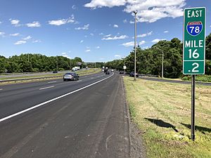
There are several major roads in Franklin Township. The most significant is Interstate 78/U.S. Route 22, which traverses through for a fifth of a mile with an interchange (Exit 15) at the northern tip of the township (which is the eastern overlapping end of Route 173). Route 12 also passes through for just less than 0.5 miles (0.80 km).
County roads that pass through include CR 513 and CR 579.
The Norfolk Southern Railway's Lehigh Line (formerly the mainline of the Lehigh Valley Railroad), runs through the northern part of Franklin Township.
Points of interest
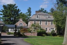
- Lansdown, a historic house in Lansdowne, was owned by Commissary-General Charles Stewart during the American Revolution. It was listed on the National Register of Historic Places in 1979.
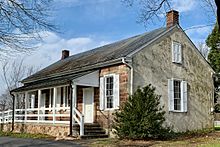
- Quaker Meeting House, a Quaker meeting house in Quakertown, was listed on the NRHP in 1990
Notable people
People who were born in, residents of, or otherwise closely associated with Franklin Township include:
- Christian Bauman (born 1970), novelist, essayist, and lyricist
- Hiram Deats (1810–1887), businessman, agricultural manufacturing
- Chris Kappler (born 1967), Olympic gold and silver medalist in equestrian events
- John J. Myers (born 1941), prelate of the Catholic Church and former Archbishop emeritus of Newark, New Jersey
- Erik Peterson (born 1966), politician who serves in the New Jersey General Assembly representing the 23rd Legislative District
- Toshiko Takaezu (1922–2011), ceramic artist and painter


