Florence County, Wisconsin facts for kids
Quick facts for kids
Florence County
|
|
|---|---|

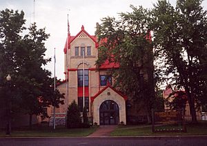
Florence County Courthouse
|
|

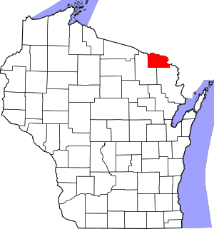
Location within the U.S. state of Wisconsin
|
|
 Wisconsin's location within the U.S. |
|
| Country | |
| State | |
| Founded | 1882 |
| Named for | Florence Terry Hulst |
| Seat | Florence |
| Largest town | Florence |
| Area | |
| • Total | 498 sq mi (1,290 km2) |
| • Land | 488 sq mi (1,260 km2) |
| • Water | 9.3 sq mi (24 km2) 1.9% |
| Population
(2020)
|
|
| • Total | 4,558 |
| • Estimate
(2023)
|
4,682 |
| • Density | 9.3/sq mi (3.6/km2) |
| Time zone | UTC−6 (Central) |
| • Summer (DST) | UTC−5 (CDT) |
| Congressional district | 7th |
Florence County is a county located in the U.S. state of Wisconsin. As of the 2020 census, the population was 4,558, making it the second-least populous county in Wisconsin after Menominee County. Its county seat is Florence.
Florence County is part of the Iron Mountain, MI–WI Micropolitan Statistical Area.
Contents
History
Florence County was created by the legislature of 1882 from portions of Marinette County and Oconto County. The first white man to document his journey through Florence County was Thomas J. Cram, who surveyed northeast Wisconsin in 1840 and 1841. The region belonged to the Menominee tribe, who mingled with the Chippewa there. Florence County continued to be a region for hunting and trapping until the 1870s when iron was discovered in the region. The Florence mine was discovered in 1874 by H. D. Fisher. In 1879, Fisher named the mine and town after the wife of Nelson Powell Hulst, Florence Terry Hulst, establishing the name for the county as well.
Geography
According to the U.S. Census Bureau, the county has a total area of 498 square miles (1,290 km2), of which 488 square miles (1,260 km2) is land and 9.3 square miles (24 km2) (1.9%) is water.
Adjacent counties
- Iron County, Michigan - north
- Dickinson County, Michigan - east
- Marinette County, Wisconsin - southeast
- Forest County, Wisconsin - southwest
Major highways
National protected area
- Nicolet National Forest (part)
Demographics
| Historical population | |||
|---|---|---|---|
| Census | Pop. | %± | |
| 1890 | 2,604 | — | |
| 1900 | 3,197 | 22.8% | |
| 1910 | 3,381 | 5.8% | |
| 1920 | 3,602 | 6.5% | |
| 1930 | 3,768 | 4.6% | |
| 1940 | 4,177 | 10.9% | |
| 1950 | 3,756 | −10.1% | |
| 1960 | 3,437 | −8.5% | |
| 1970 | 3,298 | −4.0% | |
| 1980 | 4,172 | 26.5% | |
| 1990 | 4,590 | 10.0% | |
| 2000 | 5,088 | 10.8% | |
| 2010 | 4,423 | −13.1% | |
| 2020 | 4,558 | 3.1% | |
| 2021 (est.) | 4,593 | 3.8% | |
| U.S. Decennial Census 1790–1960 1900–1990 1990–2000 2010–2020 |
|||
2020 census
As of the census of 2020, the population was 4,558. The population density was 9.3 people per square mile (3.6 people/km2). There were 4,601 housing units at an average density of 9.4 units per square mile (3.6 units/km2). The racial makeup of the county was 94.6% White, 0.7% Native American, 0.2% Black or African American, 0.2% Asian, 0.2% Pacific Islander, 0.3% from other races, and 3.9% from two or more races. Ethnically, the population was 1.4% Hispanic or Latino of any race.
Communities
Florence County is one of only two counties in Wisconsin with no incorporated communities, the other being Menominee County.
Towns
Unincorporated communities
See also
 In Spanish: Condado de Florence (Wisconsin) para niños


