Florence County, South Carolina facts for kids
Quick facts for kids
Florence County
|
|||
|---|---|---|---|

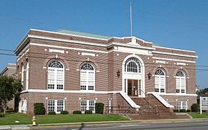
Florence Public Library
|
|||
|
|||

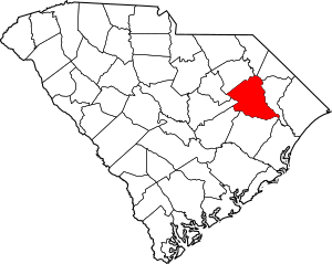
Location within the U.S. state of South Carolina
|
|||
 South Carolina's location within the U.S. |
|||
| Country | |||
| State | |||
| Founded | 1888 | ||
| Named for | Florence Harllee | ||
| Seat | Florence | ||
| Largest community | Florence | ||
| Area | |||
| • Total | 804.28 sq mi (2,083.1 km2) | ||
| • Land | 800.51 sq mi (2,073.3 km2) | ||
| • Water | 3.77 sq mi (9.8 km2) 0.47% | ||
| Population
(2020)
|
|||
| • Total | 137,059 | ||
| • Estimate
(2023)
|
137,214 |
||
| • Density | 170.4120/sq mi (65.7965/km2) | ||
| Time zone | UTC−5 (Eastern) | ||
| • Summer (DST) | UTC−4 (EDT) | ||
| Congressional districts | 6th, 7th | ||
Florence County is a county located in the U.S. state of South Carolina. As of the 2020 census, its population was 137,059. Its county seat is Florence. Florence County is included in the Florence, SC Metropolitan Statistical Area.
Contents
History
Florence County was formed from main sections of Darlington and Marion Counties plus other townships from Williamsburg and Clarendon Counties, starting in 1888. The last section of Williamsburg County was not added until 1921. Florence County was named for the daughter of General W. W. Harllee.
Geography
According to the U.S. Census Bureau, the county has a total area of 804 square miles (2,080 km2), of which 800 square miles (2,100 km2) is land and 3.8 square miles (9.8 km2) (0.5%) is water.
Adjacent counties
- Williamsburg County - south
- Marion County - east
- Dillon County - north
- Marlboro County - north
- Darlington County - northwest
- Lee County - west
- Sumter County - southwest
- Clarendon County - southwest
Major highways
Demographics
| Historical population | |||
|---|---|---|---|
| Census | Pop. | %± | |
| 1890 | 25,027 | — | |
| 1900 | 28,474 | 13.8% | |
| 1910 | 35,671 | 25.3% | |
| 1920 | 50,406 | 41.3% | |
| 1930 | 61,027 | 21.1% | |
| 1940 | 70,582 | 15.7% | |
| 1950 | 79,710 | 12.9% | |
| 1960 | 84,438 | 5.9% | |
| 1970 | 89,636 | 6.2% | |
| 1980 | 110,163 | 22.9% | |
| 1990 | 114,344 | 3.8% | |
| 2000 | 125,761 | 10.0% | |
| 2010 | 136,885 | 8.8% | |
| 2020 | 137,059 | 0.1% | |
| 2023 (est.) | 137,214 | 0.2% | |
| U.S. Decennial Census 1790–1960 1900–1990 1990–2000 2010 2020 |
|||
2020 census
| Race | Num. | Perc. |
|---|---|---|
| White | 69,021 | 50.36% |
| Black or African American | 56,877 | 41.5% |
| Native American | 330 | 0.24% |
| Asian | 2,309 | 1.68% |
| Pacific Islander | 48 | 0.04% |
| Other/Mixed | 4,191 | 3.06% |
| Hispanic or Latino | 4,283 | 3.12% |
As of the 2020 United States Census, there were 137,059 people, 53,047 households, and 35,763 families residing in the county.
2010 census
At the 2010 census, there were 136,885 people, 52,653 households, and 36,328 families living in the county. The population density was 171.1 inhabitants per square mile (66.1/km2). There were 58,666 housing units at an average density of 73.3 per square mile (28.3/km2). The racial makeup of the county was 54.9% white, 41.3% black or African American, 1.2% Asian, 0.3% American Indian, 1.1% from other races, and 1.1% from two or more races. Those of Hispanic or Latino origin made up 2.2% of the population. In terms of ancestry, 8.4% were American, 7.8% were English, 6.7% were Irish, and 6.2% were German.
Of the 52,653 households, 35.2% had children under the age of 18 living with them, 44.7% were married couples living together, 19.6% had a female householder with no husband present, 31.0% were non-families, and 26.3% of households were made up of individuals. The average household size was 2.54 and the average family size was 3.06. The median age was 37.6 years.
The median household income was $40,487 and the median family income was $48,896. Males had a median income of $38,934 versus $30,163 for females. The per capita income for the county was $21,932. About 14.5% of families and 18.0% of the population were below the poverty line, including 26.1% of those under age 18 and 14.0% of those age 65 or over.
Economy
In 2022, the GDP of Florence County was $8.5 billion (about $62,154 per capita). The real GDP was $7.2 billion (about $52,808 per capita) in chained 2017 dollars. In 2022-2024, the unemployment rate has fluctuated between 2.3-3.8%.
Duke Energy, Francis Marion University, GE HealthCare, Honda, McLeod Health, Otis Worldwide, QVC, Ruiz Foods, and Walmart are some of the largest employers in the county.
| Industry | Employment Counts | Employment Percentage (%) | Average Annual Wage ($) |
|---|---|---|---|
| Accommodation and Food Services | 7,326 | 11.1 | 20,124 |
| Administrative and Support and Waste Management and Remediation Services | 4,207 | 6.4 | 34,632 |
| Agriculture, Forestry, Fishing and Hunting | 191 | 0.3 | 49,036 |
| Arts, Entertainment, and Recreation | 661 | 1.0 | 27,768 |
| Construction | 1,800 | 2.7 | 63,024 |
| Educational Services | 4,188 | 6.3 | 48,360 |
| Finance and Insurance | 1,584 | 2.4 | 88,192 |
| Health Care and Social Assistance | 15,179 | 22.9 | 59,124 |
| Information | 569 | 0.9 | 69,732 |
| Manufacturing | 7,301 | 11.0 | 64,896 |
| Mining, Quarrying, and Oil and Gas Extraction | 34 | 0.1 | 43,420 |
| Other Services (except Public Administration) | 1,599 | 2.4 | 39,364 |
| Professional, Scientific, and Technical Services | 2,217 | 3.4 | 78,000 |
| Public Administration | 3,165 | 4.8 | 50,336 |
| Real Estate and Rental and Leasing | 844 | 1.3 | 51,636 |
| Retail Trade | 8,811 | 13.3 | 33,592 |
| Transportation and Warehousing | 3,572 | 5.4 | 46,436 |
| Utilities | 183 | 0.3 | 90,064 |
| Wholesale Trade | 2,713 | 4.1 | 65,416 |
| Total | 66,144 | 100.0% | 49,641 |
Communities
Cities
- Florence (county seat)
- Johnsonville
- Lake City
Town
Unincorporated communities
Notable people
- Roger K. Kirby (born 1960), politician
- Kent Lee (1923–2017), Navy admiral
- Georganna Sinkfield (born 1943), politician
See also
 In Spanish: Condado de Florence (Carolina del Sur) para niños


