Flaherty Island facts for kids

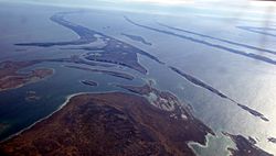
Flaherty Island from the air, looking south.
|
|
| Geography | |
|---|---|
| Location | Hudson Bay |
| Coordinates | 56°21′29″N 079°14′55″W / 56.35806°N 79.24861°W |
| Archipelago | Belcher Islands Arctic Archipelago |
| Length | 7.1 km (4.41 mi) |
| Width | 4.2 km (2.61 mi) |
| Highest elevation | 34 m (112 ft) |
| Administration | |
| Territory | Nunavut |
| Region | Qikiqtaaluk |
| Largest settlement | Sanikiluaq |
| Demographics | |
| Population | 812 |
| Ethnic groups | Inuit |
Flaherty Island is the largest island of the Belcher Islands group in Hudson Bay in Qikiqtaaluk Region, Nunavut, Canada.
The Inuit community of Sanikiluaq is located on its north coast. Sanikiluaq is the southernmost community in Nunavut.
The island is named in honour of visual anthropologist Robert J. Flaherty.
See also
 In Spanish: Isla Flaherty para niños

All content from Kiddle encyclopedia articles (including the article images and facts) can be freely used under Attribution-ShareAlike license, unless stated otherwise. Cite this article:
Flaherty Island Facts for Kids. Kiddle Encyclopedia.


