Fingal, Tasmania facts for kids
Quick facts for kids FingalTasmania |
|||||||||||||||
|---|---|---|---|---|---|---|---|---|---|---|---|---|---|---|---|

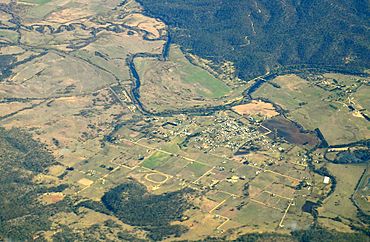
Aerial photo from south east. South Esk River visible.
|
|||||||||||||||
| Population | 431 (2021 census) | ||||||||||||||
| • Density | 79.6/km2 (206/sq mi) | ||||||||||||||
| Established | 1827 | ||||||||||||||
| Postcode(s) | 7214 | ||||||||||||||
| Elevation | 232 m (761 ft) | ||||||||||||||
| Area | 4.6 km2 (1.8 sq mi) | ||||||||||||||
| Location |
|
||||||||||||||
| LGA(s) | Break O'Day Council | ||||||||||||||
| Region | North-east | ||||||||||||||
| State electorate(s) | Lyons | ||||||||||||||
| Federal Division(s) | Lyons | ||||||||||||||
|
|||||||||||||||
Fingal /fɪŋˈɔːl/ is a rural locality in the local government area (LGA) of Break O'Day in the North-east LGA region of Tasmania. The locality is about 56 kilometres (35 mi) south-west of the town of St Helens. The 2016 census recorded a population of 405 for the state suburb of Fingal.
It is a small town in Fingal Valley in the north-east of Tasmania.
Contents
History
Fingal was gazetted as a locality in 1965.
The Fingal area was surveyed in 1824 by Roderic O'Connor and John Helder Wedge, and is believed to have been named after Fingal's Cave in the Inner Hebrides of Scotland rather than Fingal in Ireland. The town of Fingal came into existence in 1827 as a convict station, and experienced a boom when Van Diemen's Land's first payable gold was discovered in nearby Mangana.
Fingal Post Office opened on 1 June 1832.
Geography
Almost all the boundaries are survey lines. The South Esk River flows through from north to south-west.
Climate
| Climate data for Fingal (Legge Street) (237 AMSL) | |||||||||||||
|---|---|---|---|---|---|---|---|---|---|---|---|---|---|
| Month | Jan | Feb | Mar | Apr | May | Jun | Jul | Aug | Sep | Oct | Nov | Dec | Year |
| Record high °C (°F) | 41.3 (106.3) |
36.4 (97.5) |
35.7 (96.3) |
29.4 (84.9) |
25.3 (77.5) |
20.7 (69.3) |
19.2 (66.6) |
22.2 (72.0) |
29.0 (84.2) |
31.6 (88.9) |
35.4 (95.7) |
39.3 (102.7) |
41.3 (106.3) |
| Mean daily maximum °C (°F) | 23.8 (74.8) |
22.9 (73.2) |
21.6 (70.9) |
18.4 (65.1) |
15.3 (59.5) |
12.7 (54.9) |
12.2 (54.0) |
13.3 (55.9) |
15.4 (59.7) |
17.6 (63.7) |
19.8 (67.6) |
21.7 (71.1) |
17.9 (64.2) |
| Mean daily minimum °C (°F) | 10.4 (50.7) |
10.1 (50.2) |
8.2 (46.8) |
5.3 (41.5) |
2.8 (37.0) |
1.1 (34.0) |
0.6 (33.1) |
1.2 (34.2) |
3.2 (37.8) |
4.9 (40.8) |
7.2 (45.0) |
8.8 (47.8) |
5.3 (41.5) |
| Record low °C (°F) | 0.1 (32.2) |
−0.2 (31.6) |
−1.9 (28.6) |
−4.8 (23.4) |
−8.1 (17.4) |
−9 (16) |
−8.1 (17.4) |
−7.4 (18.7) |
−6.2 (20.8) |
−4.6 (23.7) |
−2.1 (28.2) |
−1.5 (29.3) |
−9 (16) |
| Average rainfall mm (inches) | 44.5 (1.75) |
40.4 (1.59) |
45.0 (1.77) |
51.1 (2.01) |
50.7 (2.00) |
65.4 (2.57) |
54.9 (2.16) |
59.8 (2.35) |
49.8 (1.96) |
53.2 (2.09) |
46.0 (1.81) |
49.7 (1.96) |
608.3 (23.95) |
| Average rainy days (≥ 0.2 mm) | 7.2 | 6.5 | 7.9 | 8.3 | 9.6 | 10.8 | 12.0 | 11.4 | 10.8 | 10.8 | 9.4 | 8.7 | 113.4 |
| Source: Bureau of Meteorology | |||||||||||||
Road infrastructure
Route A4 (Esk Main Road) runs through from south-west to north-east.


