Farmers Branch, Texas facts for kids
Quick facts for kids
Farmers Branch, Texas
|
||
|---|---|---|

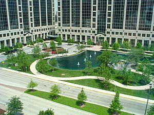
Coca-Cola Enterprises offices in Farmers Branch
|
||
|
||
| Nickname(s):
The City in a Park
|
||

Location in Dallas County and the state of Texas
|
||
| Country | ||
| State | ||
| County | ||
| First Settled | Early 1850s | |
| Incorporated | February 23, 1946 | |
| Government | ||
| • Type | Council-Manager | |
| Area | ||
| • City | 12.04 sq mi (31.18 km2) | |
| • Land | 11.88 sq mi (30.77 km2) | |
| • Water | 0.16 sq mi (0.41 km2) 0.8% | |
| Elevation | 509 ft (155 m) | |
| Population
(2020)
|
||
| • City | 35,991 | |
| • Estimate
(2021)
|
36,442 | |
| • Density | 4,053.36/sq mi (1,565.02/km2) | |
| • Urban | 5,121,892* (6th) | |
| • Metro | 7,539,711* (4th) | |
| • CSA | 7,957,493* (7th) | |
|
||
| Time zone | UTC-6 (Central) | |
| • Summer (DST) | UTC-5 (Central) | |
| ZIP code |
75234, 75244
|
|
| Area code | 214, 469, 945, 972 | |
| FIPS code | 48-25452 | |
| GNIS feature ID | 2410484 | |
| Interstates | ||
| Toll Roads | ||
| Website | farmersbranchtx.gov | |
Farmers Branch, officially the City of Farmers Branch, is a city in Dallas County, Texas, United States. It is an inner-ring suburb of Dallas and is part of the Dallas–Fort Worth metroplex. Its population was 35,991 at the 2020 census.
History
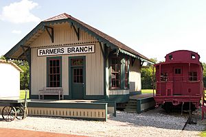
The community was first settled in the early 1850s. In 1842, Thomas Keenan, Isaac B. Webb, and William Cochran received original land grants in the area. By 1843, a community called Mustang Branch had been established. Mr. Cochran later changed the name to Farmers Branch to reflect the area's rich soil and farmland. Farmers Branch was the first location of the Texan Land and Emigration Company (or Peters Colony) in 1845. This made the community one of the best-known places in Dallas County during the 1840s because of its advertising throughout Europe and the United States. Baptist minister William Bowles opened a blacksmith shop and gristmill in 1845. On May 5, 1845, Isaac B. Webb donated land for Webb's Chapel Methodist Church, the first formal place of worship in Dallas County. A school was established in the church one year later. Webb became the first postmaster at the Farmers Branch post office, which opened on January 5, 1848. It continued to function until its closure in 1866. The post office reopened in 1875. To assure that railroads would eventually pass through Farmers Branch, prominent early settler Samuel Gilbert and others sold right-of-way through their land in 1874. Around three to four years later, the Dallas and Wichita Railway completed a track from Dallas—through Farmers Branch—to Lewisville. It was absorbed by the Missouri–Kansas–Texas Railroad in 1881. The community had a population around 100 by 1890, with several businesses. The population had grown to 300 during the early 1900s. A brick school building was constructed in 1916. The number of people living in the community remained stable until after World War II.
Farmers Branch was incorporated as a city after an election was held on February 23, 1946. William F. (Bill) Dodson was elected as the city's first mayor. The implementation of city services began immediately after incorporation. In the 1950 census, Farmers Branch had a population of 915. In 1956, a home-rule charter was approved that adopted a council-manager form of government. The rapid growth of the city during the 1950s was made apparent in the 1960 census, which recorded a total of 13,441 residents, a 1,369% increase over the 1950 figure. Most of the new residents commuted to nearby Dallas for employment. The population topped 27,000 by 1970. A variety of manufacturers producing items such as steel products, concrete, asphalt, cosmetics, and food products was operating in the city. The number of residents declined to 24,863 in 1980 and 24,250 in 1990. The falling population was offset, however, by the wide variety of businesses located in the city. Farmers Branch is home to a large number of corporations that have attained frontage along Interstate 635, the Dallas North Tollway, and Interstate 35E. Its Dallas North Tollway segment is part of the Platinum Corridor, and its land along Interstate 635 is an extension of the lengthy Irving Prairie office park. By 2000, the city's population had grown to 27,508. and by 2020 the city's population had grown to 35,991.
Geography
According to the United States Census Bureau, the city has a total area of 11.79 sq mi (30.54 km2) with only 0.08% (0.09 sq mi - 0.24 km2) covered by water.
Demographics
| Historical population | |||
|---|---|---|---|
| Census | Pop. | %± | |
| 1950 | 915 | — | |
| 1960 | 13,441 | 1,369.0% | |
| 1970 | 27,492 | 104.5% | |
| 1980 | 24,863 | −9.6% | |
| 1990 | 24,250 | −2.5% | |
| 2000 | 27,508 | 13.4% | |
| 2010 | 28,616 | 4.0% | |
| 2020 | 35,991 | 25.8% | |
| U.S. Decennial Census | |||
| Race | Number | Percentage |
|---|---|---|
| White (NH) | 12,957 | 36.0% |
| Black or African American (NH) | 2,925 | 8.13% |
| Native American or Alaska Native (NH) | 104 | 0.29% |
| Asian (NH) | 3,132 | 8.7% |
| Pacific Islander (NH) | 11 | 0.03% |
| Some Other Race (NH) | 180 | 0.5% |
| Mixed/Multi-Racial (NH) | 1,008 | 2.8% |
| Hispanic or Latino | 15,674 | 43.55% |
| Total | 35,991 |
As of the 2020 United States census, there were 35,991 people, 16,015 households, and 10,119 families residing in the city.
Economy
According to the city's 2022 Annual Comprehensive Financial Report the top employers in the city are:
| # | Employer | # of Employees |
|---|---|---|
| 1 | Internal Revenue Service | 1,200 |
| 2 | Feizy | 1,170 |
| 3 | Anserteam LLC | 1,001 |
| 4 | Telvista | 1,000 |
| 5 | TDIndustries | 900 |
| 6 | Haggar Clothing Company | 750 |
| 7 | IBM | 700 |
| 7 | MONI Smart Security | 700 |
| 9 | Encore Enterprises, Inc. | 650 |
| 9 | Glazer's Wholesale Drug Company | 650 |
As of 2012, Farmers Branch had 3,500 companies. Celanese Corporation, Eyemart Express, I2 Technologies, OxyChem, and Varsity Brands have their headquarters in Farmers Branch. Maxim Integrated Products has an office in Farmers Branch. All Smiles Dental Centers formerly had its headquarters in Farmers Branch. Excellence Health Inc. has an office in Farmers Branch that covers the Dallas life sciences cluster.
North Central Texas Council of Governments 2018 estimated total employment for the City of Farmers Branch is 78,393. The report is adjusted by the City of Farmers Branch finance department for businesses closed or moved prior to the reporting year.
Transportation
Farmers Branch was one of fifteen cities to approve services of Dallas Area Rapid Transit in 1983 by levying a 1 cent sales tax. The city currently receives DART bus service, with service to downtown Dallas (by both regular route and express bus), the adjacent suburb of Carrollton, and crosstown routes as well. On December 6, 2010, the city received light rail transit service with a station near the northeast corner of Interstates 635 and 35E on the Green Line, which runs from Pleasant Grove in southeast Dallas through downtown Dallas following I-35E up to Carrollton at Frankford Road.
The city is between Interstate 35E to the west, the Dallas North Tollway on the east, and Interstate 635 to the south.
Sister cities
Farmers Branch maintains a sister city relationship with Bassetlaw, United Kingdom, and Garbsen, Germany.
See also
 In Spanish: Farmers Branch para niños


