Fanning Springs, Florida facts for kids
Quick facts for kids
Fanning Springs, Florida
|
|
|---|---|
| City of Fanning Springs | |

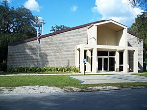
Fanning Springs City Hall
|
|
| Motto(s):
"In God We Trust"
|
|

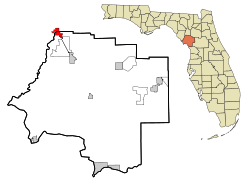
Location in Levy County and the state of Florida
|
|
| Country | |
| State | |
| Counties | Levy, Gilchrist |
| Settled (Palmetto) | c. 1846-1847 |
| Settled (Sikesville) | 1857 |
| Settled (Fannin) | 1888 |
| Incorporated (Town of Fannin Springs) | 1965 |
| Incorporated (City of Fanning Springs) |
1977 |
| Government | |
| • Type | Mayor-Council |
| Area | |
| • Total | 5.00 sq mi (12.96 km2) |
| • Land | 4.87 sq mi (12.61 km2) |
| • Water | 0.13 sq mi (0.35 km2) |
| Elevation | 30 ft (9 m) |
| Population
(2020)
|
|
| • Total | 1,182 |
| • Density | 242.76/sq mi (93.73/km2) |
| Time zone | UTC-5 (Eastern (EST)) |
| • Summer (DST) | UTC-4 (EDT) |
| ZIP code |
32693
|
| Area code(s) | 352 |
| FIPS code | 12-21850 |
| GNIS feature ID | 0291913 |
Fanning Springs is a city in Gilchrist and Levy counties in the U.S. state of Florida. It is part of the Gainesville, Florida Metropolitan Statistical Area. The population was 1,182 at the 2020 census, up from 764 at the 2010 census.
Geography
The approximate coordinates for the City of Fanning Springs is located along the Nature Coast in North Florida, (specifically North Central Florida), at 29°35′03″N 82°55′27″W / 29.584224°N 82.924160°W.
According to the United States Census Bureau, the city has a total area of 3.9 square miles (10.2 km2), of which 3.8 square miles (9.8 km2) is land and 0.12 square miles (0.3 km2), or 3.40%, is water.
Climate
The climate in this area is characterized by hot, humid summers and generally mild winters. According to the Köppen climate classification, the City of Fanning Springs has a humid subtropical climate zone (Cfa).
Demographics
| Historical population | |||
|---|---|---|---|
| Census | Pop. | %± | |
| 1970 | 115 | — | |
| 1980 | 314 | 173.0% | |
| 1990 | 493 | 57.0% | |
| 2000 | 737 | 49.5% | |
| 2010 | 764 | 3.7% | |
| 2020 | 1,182 | 54.7% | |
| U.S. Decennial Census | |||
2010 and 2020 census
| Race | Pop 2010 | Pop 2020 | % 2010 | % 2020 |
|---|---|---|---|---|
| White (NH) | 677 | 988 | 88.61% | 83.59% |
| Black or African American (NH) | 5 | 25 | 0.65% | 2.12% |
| Native American or Alaska Native (NH) | 11 | 11 | 1.44% | 0.93% |
| Asian (NH) | 5 | 14 | 0.65% | 1.18% |
| Pacific Islander or Native Hawaiian (NH) | 0 | 0 | 0.00% | 0.00% |
| Some other race (NH) | 0 | 1 | 0.00% | 0.08% |
| Two or more races/Multiracial (NH) | 7 | 50 | 0.92% | 4.23% |
| Hispanic or Latino (any race) | 59 | 93 | 7.72% | 7.87% |
| Total | 764 | 1,182 |
As of the 2020 United States census, there were 1,182 people, 457 households, and 304 families residing in the city.
As of the 2010 United States census, there were 764 people, 442 households, and 298 families residing in the city.
Attractions
The Nature Coast State Trail (being the City of Fanning Springs is part of the Nature Coast), which follows abandoned railway lines, has a junction at Fanning Springs.
Fanning Springs State Park is located just south of the center of the city, along the Suwannee River. Fort Fanning Historic Park is the site of a fort that was built in 1838 to counter Native American attacks in North Florida during the Seminole Wars.
See also
 In Spanish: Fanning Springs para niños


