Fairfield County, Ohio facts for kids
Quick facts for kids
Fairfield County
|
||
|---|---|---|

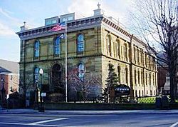
Fairfield County Courthouse
|
||
|
||

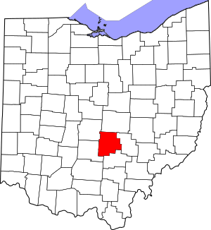
Location within the U.S. state of Ohio
|
||
 Ohio's location within the U.S. |
||
| Country | ||
| State | ||
| Founded | December 9, 1800 | |
| Named for | the Fairfield area of Lancaster, Lancashire, UK | |
| Seat | Lancaster | |
| Largest city | Lancaster | |
| Area | ||
| • Total | 509 sq mi (1,320 km2) | |
| • Land | 504 sq mi (1,310 km2) | |
| • Water | 4.2 sq mi (11 km2) 0.8%% | |
| Population
(2020)
|
||
| • Total | 158,921 | |
| • Density | 312.22/sq mi (120.55/km2) | |
| Time zone | UTC−5 (Eastern) | |
| • Summer (DST) | UTC−4 (EDT) | |
| Congressional district | 12th | |
Fairfield County is a county located in the U.S. state of Ohio. As of the 2020 census, the population was 158,921. Its county seat and largest city is Lancaster. Its name is a reference to the Fairfield area of the original Lancaster. Fairfield County is part of the Columbus, OH Metropolitan Statistical Area.
Contents
History
Fairfield County originally encompassed all or parts of present day[update] Knox, Hocking, Licking, Perry, and Pickaway Counties. Fairfield is a descriptive name referring to the beauty of their fields.
Geography
According to the U.S. Census Bureau, the county has a total area of 509 square miles (1,320 km2), of which 504 square miles (1,310 km2) is land and 4.2 square miles (11 km2) (0.8%) is water.
Fairfield County sits just on the edge of Ohio's Appalachian region. While the once-glaciated northern portion of the county is fairly flat, as one travels south along U.S. 33 one can easily recognize the foothills of a mountainous region beginning around the village of Carroll. Although not officially part of the state or federal definition of Appalachia, certain areas of Fairfield County—particularly those south of U.S. 22—bear a distinctly Appalachian feel in both physical geography and demographics.
The scenic Hocking Hills region lies immediately to the south, mostly in neighboring Hocking County. A large portion of Buckeye Lake is located in northeastern Fairfield County.
Mudhouse Mansion, an allegedly haunted house, was located in the county.
Adjacent counties
- Licking County (north)
- Perry County (east)
- Hocking County (south)
- Pickaway County (southwest)
- Franklin County (northwest)
Demographics
| Historical population | |||
|---|---|---|---|
| Census | Pop. | %± | |
| 1810 | 11,361 | — | |
| 1820 | 16,633 | 46.4% | |
| 1830 | 24,786 | 49.0% | |
| 1840 | 31,924 | 28.8% | |
| 1850 | 30,264 | −5.2% | |
| 1860 | 30,538 | 0.9% | |
| 1870 | 31,138 | 2.0% | |
| 1880 | 34,284 | 10.1% | |
| 1890 | 33,939 | −1.0% | |
| 1900 | 34,259 | 0.9% | |
| 1910 | 39,201 | 14.4% | |
| 1920 | 40,484 | 3.3% | |
| 1930 | 44,010 | 8.7% | |
| 1940 | 48,490 | 10.2% | |
| 1950 | 52,130 | 7.5% | |
| 1960 | 63,912 | 22.6% | |
| 1970 | 73,301 | 14.7% | |
| 1980 | 93,678 | 27.8% | |
| 1990 | 103,461 | 10.4% | |
| 2000 | 122,759 | 18.7% | |
| 2010 | 146,156 | 19.1% | |
| 2020 | 158,921 | 8.7% | |
| U.S. Decennial Census 1790-1960 1900-1990 1990-2000 2020 |
|||
2010 census
As of the 2010 United States Census, there were 146,156 people, 54,310 households, and 39,846 families living in the county. The population density was 289.8 inhabitants per square mile (111.9/km2). There were 58,687 housing units at an average density of 116.3 units per square mile (44.9 units/km2). The racial makeup of the county was 90.2% white, 6.0% black or African American, 1.1% Asian, 0.2% American Indian, 0.6% from other races, and 1.9% from two or more races. Those of Hispanic or Latino origin made up 1.7% of the population. In terms of ancestry, 31.2% were German, 16.2% were Irish, 11.7% were English, 8.6% were American, and 5.2% were Italian.
Of the 54,310 households, 37.3% had children under the age of 18 living with them, 57.3% were married couples living together, 11.2% had a female householder with no husband present, 26.6% were non-families, and 21.9% of all households were made up of individuals. The average household size was 2.64 and the average family size was 3.07. The median age was 38.2 years.
The median income for a household in the county was $56,796 and the median income for a family was $65,835. Males had a median income of $49,314 versus $37,209 for females. The per capita income for the county was $26,130. About 7.5% of families and 10.4% of the population were below the poverty line, including 14.7% of those under age 18 and 6.7% of those age 65 or over.
Education
School districts and state schools
School districts include:
- Amanda-Clearcreek Local School District
- Berne Union Local School District
- Bloom-Carroll Local School District
- Canal Winchester Local School District (Franklin & Fairfield)
- Fairfield Union Local School District
- Lancaster City School District
- Liberty Union-Thurston Local School District
- Northern Local School District
- Pickerington Local School District
- Reynoldsburg City School District
- Southwest Licking Local School District
- Teays Valley Local School District (Almost entirely Pickaway)
- Walnut Township Local School District
Elementary schools
- St. Mary's School
- St. Bernadette School
- Mount Pleasant Elementary
- Medill Elementary (housed at former East Elementary location during reconstruction)
- Sanderson Elementary (to be closed upon completion of Medill Elementary reconstruction)
- Tallmadge Elementary (housed at former West Elementary location during reconstruction)
- Tarhe Trails Elementary
- Gorsuch West Elementary
- Pleasantville Elementary
- Bremen Elementary
High schools
- Amanda-Clearcreek Digital Academy
- Amanda-Clearcreek High School
- Liberty Union High School
- Bloom-Carroll High School
- Fairfield Career Center
- Fairfield Christian Academy
- Fairfield Union High School
- Lancaster Fairfield Alternative School
- Lancaster High School
- Millersport Jr/Sr High School
- Walnut Township Academy
- Pickerington Alternative School
- Pickerington High School Central
- Pickerington High School North
- Berne Union High School
- William V. Fisher Catholic High School
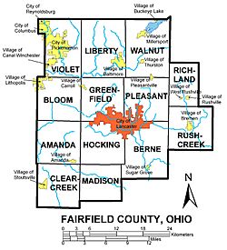
Communities
Cities
- Columbus (mostly in Franklin County and partly in Delaware County)
- Lancaster (county seat)
- Pickerington
- Reynoldsburg
- Canal Winchester
Villages
Townships
- Amanda
- Berne
- Bloom
- Clearcreek
- Greenfield
- Hocking
- Liberty
- Madison
- Pleasant
- Richland
- Rush Creek
- Violet
- Walnut
Census-designated places
Unincorporated communities
- Cedar Hill
- Clearport
- Colfax
- Delmont
- Drinkle
- Dumontsville
- Geneva
- Greencastle
- Hamburg
- Havensport
- Hooker
- Horns Mill
- Jefferson
- Lockville
- Marcy
- New Salem
- North Berne
- Oakland
- Oakthorpe
- Revenge
- Royalton
- Waterloo
Source:
See also
 In Spanish: Condado de Fairfield (Ohio) para niños


