Emu Point, Western Australia facts for kids
Quick facts for kids Emu PointAlbany, Western Australia |
|||||||||||||||
|---|---|---|---|---|---|---|---|---|---|---|---|---|---|---|---|

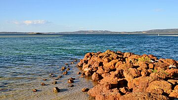
Entrance to Oyster Harbour at Emu Point
|
|||||||||||||||
| Postcode(s) | 6330 | ||||||||||||||
| Area | 1.9 km2 (0.7 sq mi) | ||||||||||||||
| Location | 8 km (5 mi) from Albany | ||||||||||||||
| LGA(s) | City of Albany | ||||||||||||||
| State electorate(s) | Albany | ||||||||||||||
| Federal Division(s) | O'Connor | ||||||||||||||
|
|||||||||||||||
Emu Point is a north-eastern suburb of Albany in southern Western Australia, north-east of Albany's central business district. Its part of the local government area of the City of Albany.
As of the 2021 census, it had a median age of 71.
History
It was the location of a spring associated with the visit of George Vancouver in the 1790s.
Emu Point was named by a survey ship in 1815.
In the early twentieth century it became a popular camping location, and has since continued as one with Big4 Emu Beach being established in 2014.
It was gazetted as a suburb in 1979.
Geography
Emu Point is a promontory that juts into the water at the channel that connects Oyster Harbour to its north with King George Sound. These two bodies of water respectively form the suburb's north-east and south-east boundaries. Its northern boundary is Yakamia Creek and in the west by Lower King Road.
Emu Beach is the largest stretch of beach in Emu Point at 2.9 kilometres (1.8 mi) long along King George Sound. The beach has been rated as one of Australia's cleanest beaches.
The northern part of the suburb is the Boronia Reserve.

