Empire, Louisiana facts for kids
Quick facts for kids
Empire, Louisiana
|
|
|---|---|
|
Census-designated place
|
|
| Country | United States |
| State | Louisiana |
| Parish | Plaquemines |
| Area | |
| • Total | 7.62 sq mi (19.72 km2) |
| • Land | 5.22 sq mi (13.51 km2) |
| • Water | 2.40 sq mi (6.21 km2) |
| Elevation | 3 ft (0.9 m) |
| Population
(2020)
|
|
| • Total | 905 |
| • Density | 173.47/sq mi (66.98/km2) |
| Time zone | UTC-6 (CST) |
| • Summer (DST) | UTC-5 (CDT) |
| ZIP Code |
70050
|
| Area code(s) | 504 |
| FIPS code | 22-23725 |
Empire is a census-designated place (CDP) in Plaquemines Parish, Louisiana, United States. The population was 905 at the 2020 census.
Seafood production
Empire, along with Venice, is the third largest seafood port in the United States by weight and value(Landings by Port Ranked by Pounds, NOAA, 2016). Some two thousand boats home port from Empire. Species landed include oysters, shrimp, menhaden, and other types of fin fish. During the BP oil spill, seafood landings came to a halt. Oyster landings did not resume for an entire year. Under the Coast 2050 plan, a 50,000 cfs freshwater diversion is proposed at Empire, which threatens the livelihood of the fishermen and the supporting businesses by drastically altering the salinity in the surrounding marshes.
Hurricane Katrina

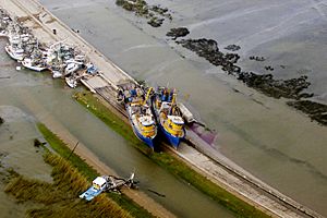
During the afternoon of August 28, 2005, Hurricane Katrina approached the northern coastline of the Gulf of Mexico, generating tropical force winds along coastal areas of Florida, Alabama, Mississippi and Louisiana. At 6:10 a.m., on August 29, 2005, Katrina made landfall just a few miles southeast of Empire, at Buras-Triumph. Many shrimp and oyster boats were grounded along the roads and levees near Empire. On the morning of August 29, the eye of the storm passed over Empire. The area was entirely flooded, causing dozens of boats that had popped their moorings to settle near the southern foot of the Empire High Rise Bridge. As a result, all traffic coming into or out of southern Plaquemines Parish was routed over the draw bridge on Parish Highway 11 (the old alignment of Louisiana Highway 23). Many notable businesses such as Tom's Place Oyster Bar and The Delta Marina were destroyed.
Geography
Empire is located at 29°23′55″N 89°36′31″W / 29.39861°N 89.60861°W (29.398586, -89.608501) and has an elevation of 3 feet (0.9 m).
According to the United States Census Bureau, the CDP has a total area of 7.6 square miles (20 km2), of which 5.2 square miles (13 km2) is land and 2.4 square miles (6.2 km2) (31.49%) is water.
Education
It is in the Plaquemines Parish School Board school district.
South Plaquemines High School is in the CDP.
Plaquemines Parish is in the service area of Nunez Community College.
Demographics
| Historical population | |||
|---|---|---|---|
| Census | Pop. | %± | |
| 2000 | 2,211 | — | |
| 2010 | 993 | −55.1% | |
| 2020 | 905 | −8.9% | |
| U.S. Decennial Census | |||
| Race / Ethnicity (NH = Non-Hispanic) | Pop 2000 | Pop 2010 | Pop 2020 | % 2000 | % 2010 | % 2020 |
|---|---|---|---|---|---|---|
| White alone (NH) | 1,335 | 650 | 464 | 60.38% | 65.46% | 51.27% |
| Black or African American alone (NH) | 743 | 212 | 218 | 33.60% | 21.35% | 24.09% |
| Native American or Alaska Native alone (NH) | 9 | 7 | 7 | 0.41% | 0.70% | 0.77% |
| Asian alone (NH) | 61 | 75 | 67 | 2.76% | 7.55% | 7.40% |
| Pacific Islander alone (NH) | 0 | 0 | 3 | 0.00% | 0.00% | 0.33% |
| Other race alone (NH) | 12 | 11 | 9 | 0.54% | 1.11% | 0.99% |
| Mixed race or Multiracial (NH) | 25 | 13 | 46 | 1.13% | 1.31% | 5.08% |
| Hispanic or Latino (any race) | 26 | 25 | 91 | 1.18% | 2.52% | 10.06% |
| Total | 2,211 | 993 | 905 | 100.00% | 100.00% | 100.00% |
See also
 In Spanish: Empire (Luisiana) para niños


