
Ebro, Florida facts for kids
Quick facts for kids
Ebro, Florida
|
|
|---|---|

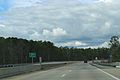
Looking northerly at the intersection of State Road 20 and State Road 79 in Ebro
|
|

Location in Washington County and the state of Florida
|
|
| Country | |
| State | |
| County | Washington |
| Settled (Spanish Florida) |
1825 |
| Incorporated | 1967 |
| Named for | Ebro River |
| Government | |
| • Type | Mayor-Council |
| Area | |
| • Total | 4.83 sq mi (12.51 km2) |
| • Land | 4.72 sq mi (12.24 km2) |
| • Water | 0.10 sq mi (0.27 km2) |
| Elevation | 75 ft (23 m) |
| Population
(2020)
|
|
| • Total | 237 |
| • Density | 50.16/sq mi (19.37/km2) |
| Time zone | UTC-6 (Central (CST)) |
| • Summer (DST) | UTC-5 (CDT) |
| ZIP code |
32437
|
| Area code(s) | 850 |
| FIPS code | 12-19725 |
| GNIS feature ID | 0282067 |
Ebro is a town in Washington County, Florida, United States. The town is part of the Florida Panhandle, and located in North Florida. As of 2020, the population recorded by the U.S. Census Bureau is 237, down from 270 at the 2010 census. It is part of the Panama City—Panama City Beach, Florida Metropolitan Statistical Area.
It is believed that during the Spanish Florida era, the Spanish named the town after the Ebro River in Spain.
Geography
The exact coordinates for the Town of Ebro is located in the southwestern part of Washington County at 30°26′35″N 85°52′51″W / 30.44306°N 85.88083°W (30.443152, –85.880790). It is the closest municipality to Northwest Florida Beaches International Airport.
Florida State Roads 20 and 79 are the main roads through the town. FL-79 runs from north to south to the east of the town, leading north 31 mi (50 km) to Bonifay along Interstate 10 and south 16 mi (26 km) to U.S. Route 98 near Panama City Beach. FL-20 runs from west to east through the center of town, leading east 51 mi (82 km) to Blountstown and west 17 mi (27 km) to Freeport.
According to the United States Census Bureau, the town has a total area of 3.2 square miles (8.3 km2). 3.2 square miles (8.3 km2) of it is land and 0.1 square miles (0.26 km2) of it (1.56%) is water.
Climate
The climate in this area is characterized by hot, humid summers and generally mild winters. According to the Köppen climate classification, the Town of Ebro has a humid subtropical climate zone (Cfa).
Demographics
| Historical population | |||
|---|---|---|---|
| Census | Pop. | %± | |
| 1970 | 125 | — | |
| 1980 | 233 | 86.4% | |
| 1990 | 255 | 9.4% | |
| 2000 | 250 | −2.0% | |
| 2010 | 270 | 8.0% | |
| 2020 | 237 | −12.2% | |
| U.S. Decennial Census | |||
2010 and 2020 census
| Race | Pop 2010 | Pop 2020 | % 2010 | % 2020 |
|---|---|---|---|---|
| White (NH) | 221 | 200 | 81.85% | 84.39% |
| Black or African American (NH) | 3 | 5 | 1.11% | 2.11% |
| Native American or Alaska Native (NH) | 15 | 9 | 5.56% | 3.80% |
| Asian (NH) | 1 | 0 | 0.37% | 0.00% |
| Pacific Islander or Native Hawaiian (NH) | 0 | 0 | 0.00% | 0.00% |
| Some other race (NH) | 0 | 0 | 0.00% | 0.00% |
| Two or more races/Multiracial (NH) | 23 | 15 | 8.52% | 6.33% |
| Hispanic or Latino (any race) | 7 | 8 | 2.59% | 3.38% |
| Total | 270 | 237 |
As of the 2020 United States census, there were 237 people, 103 households, and 65 families residing in the town.
As of the 2010 United States census, there were 270 people, 109 households, and 86 families residing in the town.
Images for kids
-
Sign for Ebro on State Route 79
-
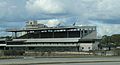
Ebro Greyhound Park


See also
 In Spanish: Ebro (Florida) para niños
