East Newark, New Jersey facts for kids
Quick facts for kids
East Newark, New Jersey
|
||
|---|---|---|
|
Borough
|
||

East Newark Borough Hall decorated for Halloween
|
||
|
||

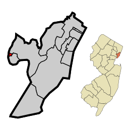
Location of East Newark in Hudson County highlighted in red (left). Inset map: Location of Hudson County in New Jersey highlighted in orange (right).
|
||

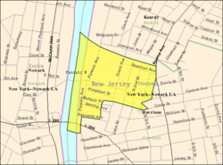
Census Bureau map of East Newark, New Jersey
|
||
| Country | ||
| State | ||
| County | ||
| Incorporated | July 2, 1895 | |
| Government | ||
| • Type | Borough | |
| • Body | Borough Council | |
| Area | ||
| • Total | 0.13 sq mi (0.32 km2) | |
| • Land | 0.10 sq mi (0.27 km2) | |
| • Water | 0.02 sq mi (0.06 km2) 16.92% | |
| Area rank | 564th of 565 in state 12th of 12 in county |
|
| Elevation | 16 ft (5 m) | |
| Population
(2020)
|
||
| • Total | 2,594 | |
| • Estimate
(2023)
|
2,428 | |
| • Rank | 464th of 565 in state 12th of 12 in county |
|
| • Density | 25,301.5/sq mi (9,769.0/km2) | |
| • Density rank | 6th of 565 in state 5th of 12 in county |
|
| Time zone | UTC−05:00 (Eastern (EST)) | |
| • Summer (DST) | UTC−04:00 (Eastern (EDT)) | |
| ZIP Code |
07029
|
|
| Area code(s) | 973 | |
| FIPS code | 3401719360 | |
| GNIS feature ID | 0885199 | |
| Website | ||
East Newark is a borough in the western part of Hudson County, in the U.S. state of New Jersey. The borough, a suburb of Newark, which sits across the Passaic River, is the second-smallest municipality by total area in the state.
The Borough of East Newark was established on July 2, 1895, from portions of Kearny lying between the Erie Railroad's Newark Branch right of way and Harrison, based on the results of a referendum held the previous day.
As of the 2020 United States census, the borough's population was 2,594, an increase of 188 (+7.8%) from the 2010 census count of 2,406, which in turn reflected an increase of 29 (+1.2%) from the 2,377 counted in the 2000 census.
Contents
Geography
According to the United States Census Bureau, the borough had a total area of 0.13 square miles (0.32 km2), including 0.10 square miles (0.27 km2) of land and 0.02 square miles (0.06 km2) of water (16.92%).
The borough is bordered to the north by Kearny and to the south and east by Harrison, both in Hudson County, and to the west by the Passaic River across from which is Newark in Essex County.
The Clark Thread Company Historic District is located in the borough.
Demographics
| Historical population | |||
|---|---|---|---|
| Census | Pop. | %± | |
| 1900 | 2,500 | — | |
| 1910 | 3,163 | 26.5% | |
| 1920 | 3,057 | −3.4% | |
| 1930 | 2,686 | −12.1% | |
| 1940 | 2,273 | −15.4% | |
| 1950 | 2,173 | −4.4% | |
| 1960 | 1,872 | −13.9% | |
| 1970 | 1,922 | 2.7% | |
| 1980 | 1,923 | 0.1% | |
| 1990 | 2,157 | 12.2% | |
| 2000 | 2,377 | 10.2% | |
| 2010 | 2,406 | 1.2% | |
| 2020 | 2,594 | 7.8% | |
| 2023 (est.) | 2,428 | 0.9% | |
| Population sources: 1900–1920 1900–1910 1910–1930 1940–2000 2000 2010 2020 |
|||
2010 census
The 2010 United States census counted 2,406 people, 759 households, and 569 families in the borough. The population density was 23,532.1 per square mile (9,085.8/km2). There were 794 housing units at an average density of 7,765.8 per square mile (2,998.4/km2). The racial makeup was 63.01% (1,516) White, 1.91% (46) Black or African American, 0.42% (10) Native American, 7.81% (188) Asian, 0.04% (1) Pacific Islander, 22.90% (551) from other races, and 3.91% (94) from two or more races. Hispanic or Latino of any race were 61.39% (1,477) of the population.
Of the 759 households, 36.6% had children under the age of 18; 45.2% were married couples living together; 18.7% had a female householder with no husband present and 25.0% were non-families. Of all households, 15.3% were made up of individuals and 4.3% had someone living alone who was 65 years of age or older. The average household size was 3.17 and the average family size was 3.38.
22.0% of the population were under the age of 18, 14.6% from 18 to 24, 32.2% from 25 to 44, 24.0% from 45 to 64, and 7.3% who were 65 years of age or older. The median age was 31.9 years. For every 100 females, the population had 101.8 males. For every 100 females ages 18 and older there were 100.1 males.
The Census Bureau's 2006–2010 American Community Survey showed that (in 2010 inflation-adjusted dollars) median household income was $54,722 (with a margin of error of +/− $5,909) and the median family income was $59,423 (+/− $9,367). Males had a median income of $41,173 (+/− $3,762) versus $28,224 (+/− $4,249) for females. The per capita income for the borough was $22,242 (+/− $2,054). About 7.9% of families and 12.5% of the population were below the poverty line, including 15.3% of those under age 18 and 16.1% of those age 65 or over.
Education
The East Newark School District serves students in pre-kindergarten through eighth grade. As of the 2021–22 school year, the district, comprised of two schools, had an enrollment of 220 students and 18.8 classroom teachers (on an FTE basis), for a student–teacher ratio of 11.7:1.
For ninth through twelfth grades, public school students attend Harrison High School in Harrison, as part of a sending/receiving relationship with the Harrison Public Schools. Citing rising tuition costs, the district announced in 2013 that it was seeking to sever its relationship with Harrison and send its students to Kearny High School, where tuition costs for students would be substantially lower than the $14,674 per student paid to Harrison for the 2012–2013 school year. In 2015, the district agreed to a new six-year sending agreement with the Harrison district under which East Newark would pay $13,000 per student, rising by 2% annually, a drop from the $16,100 cost per student paid as of the 2014–2015 school year. As of the 2021–22 school year, the high school had an enrollment of 698 students and 52.5 classroom teachers (on an FTE basis), for a student–teacher ratio of 13.3:1.
Transportation
Roads and highways
As of May 2010[update], the borough had a total of 2.71 miles (4.36 km) of roadways, of which 2.27 miles (3.65 km) were maintained by the municipality and 0.44 miles (0.71 km) by Hudson County.
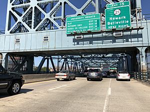
Interstate 280 passes through the southern portion of the borough. The entrances to interchange 16 lie in adjacent Harrison, and those for interchange 15B lie in Newark across the William A. Stickel Memorial Bridge over the Passaic River, which is crossed by the Clay Street Bridge.
Public transportation
NJ Transit bus service is available to Newark on the 30 and 76 routes.
The closest NJ Transit rail station to East Newark is the Newark Broad Street Station, with connections to the Montclair-Boonton Line and both branches of the Morris & Essex Lines. The station is also served by the Newark Light Rail. The closest rapid transit service is the PATH's Harrison station, a few blocks south of East Newark.
The closest airport with scheduled passenger service is Newark Liberty International Airport, located 4.8 miles (7.7 km) south in Newark and Elizabeth. John F. Kennedy International Airport and LaGuardia Airport are in Queens, New York City.
Notable people
People who were born in, residents of, or otherwise closely associated with East Newark include:
- Davey Brown (1898–1970), professional soccer player inducted into the National Soccer Hall of Fame in 1951
- Jimmy Douglas (1898–1972), soccer goalkeeper who spent his career in the first American Soccer League
- Philip Kearny (1815–1862), United States Army officer, notable for his leadership in the Mexican–American War and American Civil War
- Cornelius Augustine McGlennon (1878–1931), represented New Jersey's 8th congressional district from 1919 to 1921 and was Mayor of East Newark, New Jersey, from 1907 to 1919
- Erika Vogt (born 1973), sculptor, printmaker and video artist
See also
 In Spanish: East Newark (Nueva Jersey) para niños


