East Dubuque, Illinois facts for kids
Quick facts for kids
East Dubuque
|
|||
|---|---|---|---|

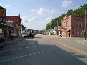
Downtown East Dubuque, along Sinsinawa Avenue
|
|||
|
|||

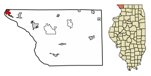
Location of East Dubuque in Jo Daviess County, Illinois.
|
|||

Location of Illinois in the United States
|
|||
| Country | United States | ||
| State | Illinois | ||
| County | Jo Daviess | ||
| Township | Dunleith | ||
| Area | |||
| • Total | 2.81 sq mi (7.29 km2) | ||
| • Land | 2.74 sq mi (7.1 km2) | ||
| • Water | 0.07 sq mi (0.19 km2) | ||
| Elevation | 610 ft (190 m) | ||
| Population
(2020)
|
|||
| • Total | 1,505 | ||
| • Density | 548.87/sq mi (211.94/km2) | ||
| Time zone | UTC-6 (CST) | ||
| • Summer (DST) | UTC-5 (CDT) | ||
| ZIP Code(s) |
61025
|
||
| Area code(s) | 815 | ||
| FIPS code | 17-21683 | ||
| GNIS ID(s) | 407631, 2394598 | ||
| Wikimedia Commons | East Dubuque, Illinois | ||
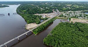
East Dubuque is a city in Jo Daviess County, Illinois, United States. The population was 1,505 at the 2020 census, down from 1,704 in 2010. East Dubuque is located alongside the Mississippi River. Across the river is the city of Dubuque, Iowa. The city limits extend along the river to the Illinois-Wisconsin border.
Contents
History
East Dubuque was originally called Dunleith, and under the latter name was platted in 1853. The present name comes from the city's location east of Dubuque. A post office was established at Dunleith in 1854, and the post office was renamed East Dubuque in 1879.
Transportation
The main roads in East Dubuque are Sinsinawa Avenue and U.S. Route 20 (Wall Street). The Julien Dubuque Bridge serves as the connection between East Dubuque and Dubuque. Illinois Route 35 serves as the primary connection between East Dubuque and Wisconsin. The East Dubuque station previously provided another transportation choice for residents of East Dubuque.
Geography
East Dubuque is located at 42°29′28″N 90°38′28″W / 42.49111°N 90.64111°W (42.491103, -90.641214).
According to the 2010 census, East Dubuque has a total area of 2.891 square miles (7.49 km2), of which 2.81 square miles (7.28 km2) (or 97.2%) is land and 0.081 square miles (0.21 km2) (or 2.8%) is water.
Like the rest of Jo Daviess County, the city is topographically a part of the Driftless Area.
Demographics
| Historical population | |||
|---|---|---|---|
| Census | Pop. | %± | |
| 1880 | 1,037 | — | |
| 1890 | 1,069 | 3.1% | |
| 1900 | 1,146 | 7.2% | |
| 1910 | 1,253 | 9.3% | |
| 1920 | 1,163 | −7.2% | |
| 1930 | 1,395 | 19.9% | |
| 1940 | 1,475 | 5.7% | |
| 1950 | 1,697 | 15.1% | |
| 1960 | 2,082 | 22.7% | |
| 1970 | 2,408 | 15.7% | |
| 1980 | 2,194 | −8.9% | |
| 1990 | 1,914 | −12.8% | |
| 2000 | 1,995 | 4.2% | |
| 2010 | 1,704 | −14.6% | |
| 2020 | 1,505 | −11.7% | |
| U.S. Decennial Census | |||
2020 census
As of the census of 2020, the population was 1,505. The population density was 548.9 inhabitants per square mile (211.9/km2). There were 771 housing units at an average density of 281.2 per square mile (108.6/km2). The racial makeup of the city was 92.5% White, 1.3% Black or African American, 0.3% Asian, 0.3% Pacific Islander, 0.2% Native American, 1.3% from other races, and 4.1% from two or more races. Ethnically, the population was 2.3% Hispanic or Latino of any race.
Notable people
- Arthur Joseph O'Neill, Roman Catholic bishop
Prominent landmarks
- East Dubuque School
- Julien Dubuque Bridge
See also
 In Spanish: East Dubuque para niños


