Donohue Peak (Yosemite) facts for kids
Quick facts for kids Donohue Peak |
|
|---|---|

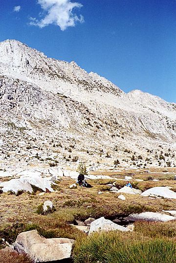
Backside of Donohue Peak
|
|
| Highest point | |
| Elevation | 12,023 ft (3,665 m) NAVD 88 |
| Prominence | 463 ft (141 m) |
| Geography | |
| Location | Yosemite National Park, Tuolumne County, California, U.S. |
| Parent range | Ritter Range, Sierra Nevada |
| Climbing | |
| First ascent | In 1895, by Sergeant Donohue, on a horse |
| Easiest route | class 1 and class 2, northwest face |
Donohue Peak is a mountain, in the northern part of Yosemite National Park. Donohue Peak is along Yosemite National Park's eastern border, in the area of Tuolumne Meadows.
On Donohue Peak's particulars
Both Donohue Pass and Lyell Canyon are nearby, as is Mount Andrea Lawrence, Johnson Peak and Rodgers Peak. Mount Ritter is south, and a bit east. The John Muir Trail passes near.
Donohue Peak is also near all of
- Peak 12223 1 mile (1.6 km)
- Blacktop Peak 3.7 miles (6.0 km)
- Kuna Peak 4.8 miles (7.7 km)
- Koip Peak 5.0 miles (8.0 km)
- Kuna Crest South 5.6 miles (9.0 km)
- Mount Lyell 5.4 miles (8.7 km)

All content from Kiddle encyclopedia articles (including the article images and facts) can be freely used under Attribution-ShareAlike license, unless stated otherwise. Cite this article:
Donohue Peak (Yosemite) Facts for Kids. Kiddle Encyclopedia.


