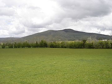
Donald's Hill facts for kids
Quick facts for kids Donald's Hill |
|
|---|---|
| Cnoc Dhónaill | |
 |
|
| Highest point | |
| Elevation | 399 m (1,309 ft) |
| Listing | Marilyn |
| Geography | |
| Location | Drumsurn, Londonderry, Northern Ireland |
| OSI/OSNI grid | C758178 |
Donald's Hill (Irish: Cnoc Dhónaill) is a hill in County Londonderry, Northern Ireland. The summit reaches 399 metres above sea level and classifies as a Marilyn. Located at the edge of the Sperrin Mountains, the village of Drumsurn sits at the foot of the hill.
The Ordnance Survey Memoirs of 1834 records an alternative name of Knocknahurkle, which is believed to be derived from Irish Cnoc na hEarcola.
An ignimbrite formation can be found at the western edge of the plateau with approximately 30 kilometres of outcrop between Donald's Hill and Magherafelt.
Donald's Hill lies on the route of the North Sperrins Way section of the Ulster Way long distance walking circuit.
Links

All content from Kiddle encyclopedia articles (including the article images and facts) can be freely used under Attribution-ShareAlike license, unless stated otherwise. Cite this article:
Donald's Hill Facts for Kids. Kiddle Encyclopedia.
