Dodge County, Nebraska facts for kids
Quick facts for kids
Dodge County
|
|
|---|---|

Dodge County Courthouse in Fremont
|
|

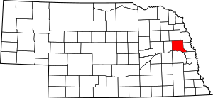
Location within the U.S. state of Nebraska
|
|
 Nebraska's location within the U.S. |
|
| Country | |
| State | |
| Founded | 1855 |
| Named for | Augustus C. Dodge |
| Seat | Fremont |
| Largest city | Fremont |
| Area | |
| • Total | 543 sq mi (1,410 km2) |
| • Land | 529 sq mi (1,370 km2) |
| • Water | 14 sq mi (40 km2) 2.6%% |
| Population
(2020)
|
|
| • Total | 37,167 |
| • Density | 68.45/sq mi (26.428/km2) |
| Time zone | UTC−6 (Central) |
| • Summer (DST) | UTC−5 (CDT) |
| Congressional district | 1st |
Dodge County is a county in the U.S. state of Nebraska. As of the 2020 United States Census, the population was 37,167. Its county seat is Fremont. The county was formed in 1855 and named after Iowa Senator Augustus C. Dodge.
Dodge County comprises the Fremont, NE Micropolitan Statistical Area, which is also included in the Omaha-Council Bluffs-Fremont, NE-IA Combined Statistical Area.
In the Nebraska license plate system, Dodge County is represented by the prefix 5 (it had the fifth-largest number of vehicles registered in the county when the license plate system was established in 1922).
Contents
Geography
The Elkhorn River runs through the NE part of Dodge County. It drains into the Platte River below the SE corner of the county. The Platte River runs along the south line of Dodge County.
According to the US Census Bureau, the county has an area of 543 square miles (1,410 km2), of which 529 square miles (1,370 km2) is land and 14 square miles (36 km2) (2.6%) is water.
Major highways
Transit
- Express Arrow
Adjacent counties
- Burt County – northeast
- Washington County – east
- Douglas County – southeast
- Saunders County – south
- Colfax County – west
- Cuming County – north
Demographics
| Historical population | |||
|---|---|---|---|
| Census | Pop. | %± | |
| 1860 | 309 | — | |
| 1870 | 4,212 | 1,263.1% | |
| 1880 | 11,263 | 167.4% | |
| 1890 | 19,260 | 71.0% | |
| 1900 | 22,298 | 15.8% | |
| 1910 | 22,145 | −0.7% | |
| 1920 | 23,197 | 4.8% | |
| 1930 | 25,273 | 8.9% | |
| 1940 | 23,799 | −5.8% | |
| 1950 | 26,265 | 10.4% | |
| 1960 | 32,471 | 23.6% | |
| 1970 | 34,782 | 7.1% | |
| 1980 | 35,847 | 3.1% | |
| 1990 | 34,500 | −3.8% | |
| 2000 | 36,160 | 4.8% | |
| 2010 | 36,691 | 1.5% | |
| 2020 | 37,167 | 1.3% | |
| 2023 (est.) | 37,187 | 1.4% | |
| US Decennial Census | |||
As of the 2000 United States Census, there were 36,160 people, 14,433 households, and 9,756 families in the county. The population density was 68 people per square mile (26 people/km2). There were 15,468 housing units at an average density of 29 units per square mile (11/km2). The racial makeup of the county was 95.90% White, 0.43% Black or African American, 0.30% Native American, 0.51% Asian, 0.09% Pacific Islander, 2.06% from other races, and 0.72% from two or more races. 3.93% of the population were Hispanic or Latino of any race. 48.1% were of German, 7.6% Irish, 5.7% English and 5.4% American ancestry.
There were 14,433 households, out of which 31.10% had children under the age of 18 living with them, 55.80% were married couples living together, 8.50% had a female householder with no husband present, and 32.40% were non-families. 27.60% of all households were made up of individuals, and 13.40% had someone living alone who was 65 years of age or older. The average household size was 2.42 and the average family size was 2.95.
The county population contained 24.70% under the age of 18, 9.60% from 18 to 24, 26.20% from 25 to 44, 21.90% from 45 to 64, and 17.50% who were 65 years of age or older. The median age was 38 years. For every 100 females there were 93.20 males. For every 100 females age 18 and over, there were 90.00 males.
The median income for a household in the county was $37,188, and the median income for a family was $44,790. Males had a median income of $31,108 versus $20,915 for females. The per capita income for the county was $17,757. About 5.30% of families and 8.60% of the population were below the poverty line, including 10.30% of those under age 18 and 7.10% of those age 65 or over.
Communities
Cities
- Fremont (county seat)
- Hooper
- North Bend
- Scribner
Villages
Census-designated place
Other unincorporated communities
Bygone cities
- Jalapa
Townships
- Cotterell
- Cuming
- Elkhorn
- Everett
- Hooper
- Logan
- Maple
- Nickerson
- Pebble
- Platte
- Pleasant Valley
- Ridgeley
- Union
- Webster
See also
 In Spanish: Condado de Dodge (Nebraska) para niños

