Delta County, Colorado facts for kids
Quick facts for kids
Delta County
|
|
|---|---|

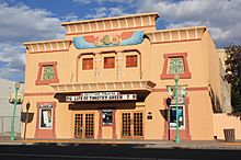
Egyptian Theatre (Delta, Colorado)
|
|

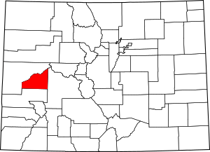
Location within the U.S. state of Colorado
|
|
 Colorado's location within the U.S. |
|
| Country | |
| State | |
| Founded | February 11, 1883 |
| Named for | City of Delta, Colorado |
| Seat | Delta |
| Largest city | Delta |
| Area | |
| • Total | 1,149 sq mi (2,980 km2) |
| • Land | 1,142 sq mi (2,960 km2) |
| • Water | 6.5 sq mi (17 km2) 0.6%% |
| Population
(2020)
|
|
| • Total | 31,196 |
| • Estimate
(2023)
|
31,746 |
| • Density | 27/sq mi (10/km2) |
| Time zone | UTC−7 (Mountain) |
| • Summer (DST) | UTC−6 (MDT) |
| Congressional district | 3rd |

Delta County is a county located in the U.S. state of Colorado. As of the 2020 census, the population was 31,196. The county seat is Delta.
Contents
History
Delta County was created by the Colorado legislature on February 11, 1883, out of portions of central Gunnison County. The county was named from a delta of arable land at the mouth of the Uncompahgre River, where it flows into the Gunnison River.
Geography
According to the U.S. Census Bureau, the county has a total area of 1,149 square miles (2,980 km2), of which 1,142 square miles (2,960 km2) is land and 6.5 square miles (17 km2) (0.6%) is water.
Adjacent counties
- Mesa County – northwest
- Gunnison County – east
- Montrose County – south
Major highways
National protected areas
- Dominguez Canyon Wilderness
- Dominguez-Escalante National Conservation Area (part)
- Grand Mesa National Forest
- Gunnison Gorge National Conservation Area (part)
- Gunnison Gorge Wilderness
- Gunnison National Forest
State protected areas
- Crawford State Park
- Sweitzer Lake State Park
Trails and byways
- American Discovery Trail
- Crag Crest National Recreation Trail
- Old Spanish National Historic Trail
- Grand Mesa Scenic and Historic Byway
- West Elk Loop Scenic Byway
Demographics
| Historical population | |||
|---|---|---|---|
| Census | Pop. | %± | |
| 1890 | 2,534 | — | |
| 1900 | 5,487 | 116.5% | |
| 1910 | 13,688 | 149.5% | |
| 1920 | 13,668 | −0.1% | |
| 1930 | 14,204 | 3.9% | |
| 1940 | 16,470 | 16.0% | |
| 1950 | 17,365 | 5.4% | |
| 1960 | 15,602 | −10.2% | |
| 1970 | 15,286 | −2.0% | |
| 1980 | 21,225 | 38.9% | |
| 1990 | 20,980 | −1.2% | |
| 2000 | 27,834 | 32.7% | |
| 2010 | 30,952 | 11.2% | |
| 2020 | 31,196 | 0.8% | |
| 2023 (est.) | 31,746 | 2.6% | |
| U.S. Decennial Census 1790-1960 1900-1990 1990-2000 2010-2020 |
|||
At the 2000 census there were 27,834 people, 11,058 households, and 7,939 families living in the county. The population density was 24 people per square mile (9.3 people/km2). There were 12,374 housing units at an average density of 11 units per square mile (4.2 units/km2). The racial makeup of the county was 92.29% White, 0.52% Black or African American, 0.76% Native American, 0.32% Asian, 0.03% Pacific Islander, 4.25% from other races, and 1.83% from two or more races. 11.39% of the population were Hispanic or Latino of any race. Of the 11,058 households 29.00% had children under the age of 18 living with them, 60.30% were married couples living together, 7.90% had a female householder with no husband present, and 28.20% were non-families. 24.80% of households were one person and 12.40% were one person aged 65 or older. The average household size was 2.43 and the average family size was 2.89.
The age distribution was 24.00% under the age of 18, 6.30% from 18 to 24, 23.60% from 25 to 44, 26.50% from 45 to 64, and 19.70% 65 or older. The median age was 42 years. For every 100 females there were 100.80 males. For every 100 females age 18 and over, there were 98.60 males.
The median household income was $32,785 and the median family income was $37,748. Males had a median income of $31,348 versus $19,916 for females. The per capita income for the county was $17,152. About 8.50% of families and 12.10% of the population were below the poverty line, including 15.00% of those under age 18 and 9.60% of those age 65 or over.
Communities
City
Towns
Census Designated Place
Unincorporated communities
Media
The local papers are the Delta County Independent and the Merchant Herald.
Education
The county is served by Delta County Joint School District 50-J.
Elementary Schools
- Cedaredge Elementary School
- Garnet Mesa Elementary School (Delta)
- Hotchkiss K-8 School
- Lincoln Elementary School (Delta)
- Paonia K-8 School
Middle Schools
- Cedaredge Middle School
- Delta Middle School
- Hotchkiss K-8 School
- Paonia K-8 School
High Schools
- Cedaredge High School
- Delta High School
- North Fork High School (Hotchkiss)
Higher Education
Technical College of the Rockies, a trade school offering technical training and professional certificates, is located in the city of Delta.
See also
 In Spanish: Condado de Delta (Colorado) para niños


