Delaware Boundary Markers facts for kids
Quick facts for kids |
|
|
Delaware Boundary Markers
|
|

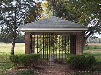
Mason–Dixon Monument, October 2011
|
|
| Lua error in Module:Location_map at line 420: attempt to index field 'wikibase' (a nil value). | |
| Location | State boundary lines between DE-MD/DE-PA, Delaware |
|---|---|
| Area | 0 acres (0 ha) |
| Built | 1763 |
| Architect | Mason, Charles; Dixon, Jeremiah |
| NRHP reference No. | 75002101 |
| Added to NRHP | February 18, 1975 |
Delaware Boundary Markers is a national historic district located on the State boundary lines between Delaware, Maryland, and Pennsylvania. The district includes 94 contributing sites along the Mason–Dixon line and includes the Transpeninsular Line, "Post Marked West" site, Mason–Dixon line, Tangent Line, The Arc, and The Twelve-Mile Circle.
It was added to the National Register of Historic Places in 1975.

All content from Kiddle encyclopedia articles (including the article images and facts) can be freely used under Attribution-ShareAlike license, unless stated otherwise. Cite this article:
Delaware Boundary Markers Facts for Kids. Kiddle Encyclopedia.