Deggendorf (district) facts for kids
Quick facts for kids
Deggendorf
|
||
|---|---|---|
|
||
| Country | ||
| State | Bavaria | |
| Adm. region | Lower Bavaria | |
| Region | Donau-Wald | |
| Capital | Deggendorf | |
| Area | ||
| • Total | 861 km2 (332 sq mi) | |
| Population
(2000)
|
||
| • Total | 115,500 | |
| • Density | 134.15/km2 (347.4/sq mi) | |
| Time zone | UTC+1 (CET) | |
| • Summer (DST) | UTC+2 (CEST) | |
| Vehicle registration | DEG | |
| Website | landkreis-deggendorf.de | |
Deggendorf is a Landkreis (district) in Bavaria, Germany.
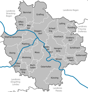
The Danube river runs through the district from west to east. The Isar river enters in the south and meets the Danube close to the town of Deggendorf. The Einödriegel (1,220 m) is the highest point within the district.
Towns and municipalities
| Towns | Municipalities | |
|---|---|---|
|
|
|
See also
 In Spanish: Distrito de Deggendorf para niños

All content from Kiddle encyclopedia articles (including the article images and facts) can be freely used under Attribution-ShareAlike license, unless stated otherwise. Cite this article:
Deggendorf (district) Facts for Kids. Kiddle Encyclopedia.


