Cunurana (Melgar) facts for kids
Quick facts for kids Cunurana |
|
|---|---|

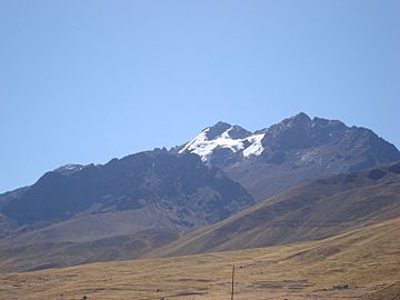
Cunurana as seen from Santa Rosa
|
|
| Highest point | |
| Elevation | 5,420 m (17,780 ft) |
| Geography | |
| Location | Peru, Puno Region |
| Parent range | Andes, La Raya |
Cunurana (possibly from Aymara for a variety of potato of the qhini group) is a mountain in the La Raya mountain range in the Andes of Peru, about 5,420 metres (17,782 ft) high. It is situated in the Puno Region, Melgar Province, Santa Rosa District. Cunurana lies south east of La Raya mountain pass near the road and railway that connect Cusco and Juliaca.
See also
 In Spanish: Cunurana (Melgar) para niños

All content from Kiddle encyclopedia articles (including the article images and facts) can be freely used under Attribution-ShareAlike license, unless stated otherwise. Cite this article:
Cunurana (Melgar) Facts for Kids. Kiddle Encyclopedia.
