Cumberland County, Maine facts for kids
Quick facts for kids
Cumberland County
|
||
|---|---|---|

|
||
|
||

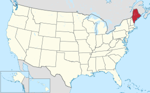
Location within the U.S. state of Maine
|
||
 Maine's location within the U.S. |
||
| Country | ||
| State | ||
| Founded | November 1, 1760 | |
| Named for | Prince William, Duke of Cumberland | |
| Seat | Portland | |
| Largest city | Portland | |
| Area | ||
| • Total | 1,217 sq mi (3,150 km2) | |
| • Land | 835 sq mi (2,160 km2) | |
| • Water | 383 sq mi (990 km2) 31%% | |
| Population
(2020)
|
||
| • Total | 303,069 | |
| • Estimate
(2021)
|
305,231 |
|
| • Density | 249.03/sq mi (96.15/km2) | |
| Time zone | UTC−5 (Eastern) | |
| • Summer (DST) | UTC−4 (EDT) | |
| Congressional district | 1st | |
Cumberland County is a county in the U.S. state of Maine. As of the 2020 census, the population was 303,069, making it the most populous county in Maine. Its county seat is Portland. Cumberland County was founded in 1760 from a portion of York County, Province of Massachusetts Bay, and named for William, Duke of Cumberland, a son of King George II. Cumberland County has the deepest and second-largest body of water in the state, Sebago Lake, which supplies tap water to most of the county. The county is the state's economic and industrial center, having the resources of the Port of Portland, the Maine Mall, and having corporate headquarters of major companies such as onsemi, IDEXX Laboratories, Unum, and TD Bank. Cumberland County is part of the Portland–South Portland, ME Metropolitan Statistical Area.
Contents
Geography
According to the U.S. Census Bureau, the county has a total area of 1,217 square miles (3,150 km2), of which 835 square miles (2,160 km2) is land and 382 square miles (990 km2) (31%) is water.
Most of Casco Bay and most of its islands east of East Cundy Point belong to the county's territory, as does the northernmost part of Saco Bay. Sebago Lake flows into Casco Bay via the Presumpscot River, and Nonesuch River flows into Saco Bay. North and west of Sebago Lake, the terrain of the county begins to flow into the foothills of the Appalachian Mountain range.
Adjacent counties
- Androscoggin County – north
- Oxford County – northwest
- Sagadahoc County – northeast
- York County – southwest
Major highways
National protected area
Demographics
| Historical population | |||
|---|---|---|---|
| Census | Pop. | %± | |
| 1790 | 25,530 | — | |
| 1800 | 38,208 | 49.7% | |
| 1810 | 42,831 | 12.1% | |
| 1820 | 49,445 | 15.4% | |
| 1830 | 60,102 | 21.6% | |
| 1840 | 68,658 | 14.2% | |
| 1850 | 79,538 | 15.8% | |
| 1860 | 75,591 | −5.0% | |
| 1870 | 82,021 | 8.5% | |
| 1880 | 86,359 | 5.3% | |
| 1890 | 90,949 | 5.3% | |
| 1900 | 100,689 | 10.7% | |
| 1910 | 112,014 | 11.2% | |
| 1920 | 124,376 | 11.0% | |
| 1930 | 134,645 | 8.3% | |
| 1940 | 146,000 | 8.4% | |
| 1950 | 169,201 | 15.9% | |
| 1960 | 182,751 | 8.0% | |
| 1970 | 192,528 | 5.3% | |
| 1980 | 215,789 | 12.1% | |
| 1990 | 243,135 | 12.7% | |
| 2000 | 265,612 | 9.2% | |
| 2010 | 281,674 | 6.0% | |
| 2020 | 303,069 | 7.6% | |
| 2023 (est.) | 310,230 | 10.1% | |
| U.S. Decennial Census 1790–1960 1900–1990 1990–2000 2010–2019 |
|||
2010 census
As of the 2010 United States Census, there were 281,674 people, 117,339 households, and 70,778 families living in the county. The population density was 337.2 inhabitants per square mile (130.2/km2). There were 138,657 housing units at an average density of 166.0 per square mile (64.1/km2). The racial makeup of the county was 92.8% white, 2.4% black or African American, 2.0% Asian, 0.3% American Indian, 0.6% from other races, and 1.8% from two or more races. Those of Hispanic or Latino origin made up 1.8% of the population. In terms of ancestry, 22.7% were English, 21.1% were Irish, 9.0% were German, 8.4% were Italian, 6.0% were Scottish, 5.5% were French Canadian, and 4.4% were American.
Of the 117,339 households, 28.3% had children under the age of 18 living with them, 46.8% were married couples living together, 9.7% had a female householder with no husband present, 39.7% were non-families, and 29.7% of all households were made up of individuals. The average household size was 2.32 and the average family size was 2.90. The median age was 41.0 years.
The median income for a household in the county was $55,658 and the median income for a family was $71,335. Males had a median income of $48,158 versus $38,539 for females. The per capita income for the county was $31,041. About 6.9% of families and 10.5% of the population were below the poverty line, including 14.4% of those under age 18 and 7.5% of those age 65 or over.
Communities
Cities
- Portland (county seat)
- South Portland
- Westbrook
Towns
Census-designated places
- Bridgton
- Brunswick
- Brunswick Station
- Casco
- Cousins Island
- Cumberland Center
- Dunstan
- Falmouth
- Falmouth Foreside
- Freeport
- Gorham
- Gray
- Little Falls
- Littlejohn Island
- Naples
- North Windham
- Oak Hill (known as "Scarborough" prior to 2020)
- Standish
- Steep Falls
- South Windham
- Yarmouth
Other unincorporated communities
- Bailey Island
- Higgins Beach
- North Bridgton
- Orr's Island
- Prouts Neck
- Sebago Lake
- South Casco
- South Freeport
Education
School districts include:
- Brunswick School District
- Cape Elizabeth School District
- Chebeague Island School District
- Falmouth School District
- Gorham School District
- Long Island School District
- Portland Public Schools
- Regional School Unit 05
- Regional School Unit 14
- Scarborough School District
- School Administrative District 06
- School Administrative District 15
- School Administrative District 17
- School Administrative District 55
- School Administrative District 61
- School Administrative District 51
- School Administrative District 75
- Sebago Public Schools
- South Portland School District
- Westbrook School District
- Yarmouth School District
Governor Baxter School for the Deaf, a state-owned school, is in the county.
See also
 In Spanish: Condado de Cumberland (Maine) para niños


