Cucharas Pass facts for kids
This page is about the mountain pass. For other places in Colorado, see Cuchara.
Quick facts for kids Cucharas Pass |
|
|---|---|

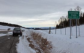
The pass in December, 2012.
|
|
| Elevation | 9,938 ft (3,029 m) |
| Traversed by | |
| Location | Las Animas / Huerfano counties, Colorado, United States |
| Range | Sangre de Cristo Mountains |
| Coordinates | 37°19′13″N 105°04′25″W / 37.32028°N 105.07361°W |
| Topo map | USGS Cucharas Pass |
Cucharas Pass is a 9,938 ft (3,029 m) elevation mountain pass in the Sangre de Cristo Mountains in south central Colorado in the United States.
At the top, the pass is signed as Cuchara Pass and the elevation on the sign there reads 9995 ft. State Highway 12 traverses the pass. Highway 12 is also signed as the Highway of Legends Scenic Byway, one of Colorado's Scenic and Historic Byways.
The region gets its name from the spoon-like shape of the valley, with "cuchara" being the Spanish word for "spoon."

All content from Kiddle encyclopedia articles (including the article images and facts) can be freely used under Attribution-ShareAlike license, unless stated otherwise. Cite this article:
Cucharas Pass Facts for Kids. Kiddle Encyclopedia.