Crystola, Colorado facts for kids
Quick facts for kids
Crystola, Colorado
|
|
|---|---|

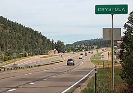
Crystola and U.S. Highway 24.
|
|
| Country | |
| State | |
| County | El Paso County Teller County |
| Elevation | 7,979 ft (2,432 m) |
| Time zone | UTC-7 (MST) |
| • Summer (DST) | UTC-6 (MDT) |
| ZIP code |
80863 (Woodland Park)
|
| Area code(s) | 719 |
| GNIS feature ID | 0191202 |
Crystola is an unincorporated community in El Paso and Teller counties, Colorado, United States. ZIP code 80863 serves Crystola, but mail must be addressed to Woodland Park.
On 27 June 2012, the town came under a mandatory evacuation notice due to the Waldo Canyon Fire.
Geography
Crystola is located at 38°57′21″N 105°01′38″W / 38.95583°N 105.02722°W (38.9558243,-105.0272053).

All content from Kiddle encyclopedia articles (including the article images and facts) can be freely used under Attribution-ShareAlike license, unless stated otherwise. Cite this article:
Crystola, Colorado Facts for Kids. Kiddle Encyclopedia.

