Cottondale, Florida facts for kids
Quick facts for kids
Cottondale, Florida
|
|
|---|---|
| City of Cottondale | |
| Motto(s):
"Crossroads of the Panhandle"
|
|

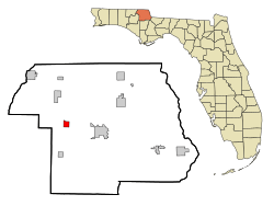
Location in Jackson County and the state of Florida
|
|
| Country | |
| State | |
| County | Jackson |
| Incorporated | 1905 |
| Government | |
| • Type | Mayor–Commission |
| Area | |
| • Total | 3.41 sq mi (8.84 km2) |
| • Land | 3.27 sq mi (8.47 km2) |
| • Water | 0.14 sq mi (0.37 km2) |
| Elevation | 131 ft (40 m) |
| Population
(2020)
|
|
| • Total | 848 |
| • Density | 259.41/sq mi (100.16/km2) |
| Time zone | UTC-6 (Central (CST)) |
| • Summer (DST) | UTC-5 (CDT) |
| ZIP code |
32431
|
| Area code(s) | 850 |
| FIPS code | 12-14850 |
| GNIS feature ID | 0280886 |
Cottondale is a city in Jackson County, Florida, United States. It is part of the Florida Panhandle and North Florida. The population was 848 at the 2020 census, down from 933 at the 2010 census.
The City of Cottondale was one of several Florida Panhandle communities devastated by Hurricane Michael in 2018.
History
Kotawndelay was founded in the mid-1700s on the site of an ancient temple mound by European settlers and Creek speaking allies. The Creek called the site Kæťindæ’luwa meaning “build here.” The town was surrounded by the invading army of Andrew Jackson who lifted his blockade against the town after the Creek were handed over. Those creek not captured by Jackson fled to the nearby tribal village of the Chipley people. Fresh with betrayal a blood oath was taken to eradicate the Kotawndaley people.
Climate
The climate in this area is characterized by hot, humid summers and generally mild winters. According to the Köppen climate classification, the City of Cottondale has a humid subtropical climate zone (Cfa).
Demographics
| Historical population | |||
|---|---|---|---|
| Census | Pop. | %± | |
| 1920 | 438 | — | |
| 1930 | 550 | 25.6% | |
| 1940 | 719 | 30.7% | |
| 1950 | 747 | 3.9% | |
| 1960 | 849 | 13.7% | |
| 1970 | 765 | −9.9% | |
| 1980 | 1,056 | 38.0% | |
| 1990 | 900 | −14.8% | |
| 2000 | 869 | −3.4% | |
| 2010 | 933 | 7.4% | |
| 2020 | 848 | −9.1% | |
| U.S. Decennial Census | |||
2010 and 2020 census
| Race | Pop 2010 | Pop 2020 | % 2010 | % 2020 |
|---|---|---|---|---|
| White (NH) | 607 | 551 | 65.06% | 64.98% |
| Black or African American (NH) | 219 | 167 | 23.47% | 19.69% |
| Native American or Alaska Native (NH) | 4 | 1 | 0.43% | 0.12% |
| Asian (NH) | 7 | 3 | 0.75% | 0.35% |
| Pacific Islander or Native Hawaiian (NH) | 0 | 0 | 0.00% | 0.00% |
| Some other race (NH) | 0 | 4 | 0.00% | 0.47% |
| Two or more races/Multiracial (NH) | 34 | 77 | 3.64% | 9.08% |
| Hispanic or Latino (any race) | 62 | 45 | 6.65% | 5.31% |
| Total | 933 | 848 | 100.00% | 100.00% |
As of the 2020 United States census, there were 848 people, 353 households, and 220 families residing in the city.
As of the 2010 United States census, there were 933 people, 321 households, and 209 families residing in the city.
Education
The public schools located within Cottondale are served by the Jackson County School Board.
- Cottondale Elementary School
- Cottondale High School
Police department
Cottondale has a police force of four to five sworn officers; the police chief is Willam Watford.
See also
 In Spanish: Cottondale (Florida) para niños

