Cornelius, Oregon facts for kids
Quick facts for kids
Cornelius, Oregon
|
|
|---|---|

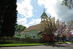
Virginia Garcia Memorial Health Center
|
|
| Nickname(s):
Oregon's Family Town
|
|

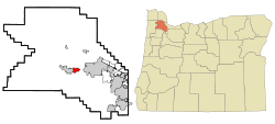
Location in Oregon
|
|
| Country | United States |
| State | Oregon |
| County | Washington |
| Incorporated | 1893 |
| Government | |
| • Type | Council–manager |
| Area | |
| • Total | 2.34 sq mi (6.06 km2) |
| • Land | 2.34 sq mi (6.06 km2) |
| • Water | 0.00 sq mi (0.00 km2) |
| Elevation | 180 ft (50 m) |
| Population
(2020)
|
|
| • Total | 12,694 |
| • Density | 5,427.11/sq mi (2,095.42/km2) |
| Time zone | UTC-8 (Pacific) |
| • Summer (DST) | UTC-7 (Pacific) |
| ZIP code |
97113
|
| Area code(s) | 503, 971 |
| FIPS code | 41-15550 |
| GNIS feature ID | 2410230 |
Cornelius is a city in Washington County, Oregon, United States. Located in the Portland metropolitan area, the city's population was 11,869 at the 2010 census. The city lies along Tualatin Valley Highway between Forest Grove to the west and Hillsboro to the east. Cornelius was incorporated in 1893 and is named for founder Thomas R. Cornelius.
History
In 1845, Benjamin Cornelius immigrated to Oregon with his family, traveling with Joseph Meek. The Cornelius family settled on the Tualatin Plains, near what is now North Plains. The same year, Benjamin Q. Tucker and Solomon Emerick staked land claims and established farms on the land that would eventually become Cornelius. At that time, the area was called Free Orchards; there was no actual community, but the name referred to the orchards on the 107 acres (0.43 km2) of land.
In 1871, Benjamin Cornelius's son Colonel Thomas R. Cornelius learned that Ben Holladay planned to extend the Oregon and California Railroad right through Free Orchards. Holladay had been told by Forest Grove and Hillsboro that they would not allow the railroad free right-of-way, so Holladay planned to bypass them, and build Free Orchards into a new city that would become the new county seat of Washington County.
The new railroad was approaching Free Orchards in 1871, and Cornelius saw an opportunity to benefit from the new railroad. He left his farm and built a new house, a warehouse, and a store in Free Orchards. The warehouse and store were located right next to the railroad, and so became natural places for local farmers to trade and store their goods. Cornelius also built a creamery to process milk, and two sawmills to supply lumber for the growing community. In addition, he helped to build the first frame schoolhouse and the Methodist Church.
In 1893, Free Orchards was incorporated and renamed "Cornelius", to honor the man who spent many years helping build the community. Though Holladay's plan to make Free Orchards into the county seat never materialized, Cornelius survives today as an agricultural town and, increasingly, as a suburb of Portland. The Cornelius Public Library was founded in 1912.
Geography
According to the United States Census Bureau, the city has a total area of 2.01 square miles (5.21 km2), all land.
Demographics
| Historical population | |||
|---|---|---|---|
| Census | Pop. | %± | |
| 1900 | 246 | — | |
| 1910 | 459 | 86.6% | |
| 1920 | 282 | −38.6% | |
| 1930 | 265 | −6.0% | |
| 1940 | 637 | 140.4% | |
| 1950 | 998 | 56.7% | |
| 1960 | 1,146 | 14.8% | |
| 1970 | 1,903 | 66.1% | |
| 1980 | 4,462 | 134.5% | |
| 1990 | 6,148 | 37.8% | |
| 2000 | 9,652 | 57.0% | |
| 2010 | 11,869 | 23.0% | |
| 2020 | 12,694 | 7.0% | |
| U.S. Decennial Census | |||
2010 census
As of the census of 2010, there were 11,869 people, 3,339 households, and 2,666 families living in the city. The population density was 5,905.0 inhabitants per square mile (2,279.9/km2). There were 3,499 housing units at an average density of 1,740.8 per square mile (672.1/km2). The racial makeup of the city was 64.0% White, 1.2% African American, 1.3% Native American, 2.2% Asian, 0.1% Pacific Islander, 27.2% from other races, and 4.0% from two or more races. Hispanic or Latino of any race were 50.1% of the population.
There were 3,339 households, of which 51.8% had children under the age of 18 living with them, 62.1% were married couples living together, 10.5% had a female householder with no husband present, 7.3% had a male householder with no wife present, and 20.2% were non-families. 14.1% of all households were made up of individuals, and 5.1% had someone living alone who was 65 years of age or older. The average household size was 3.51 and the average family size was 3.88.
The median age in the city was 30.4 years. 32.9% of residents were under the age of 18; 9.8% were between the ages of 18 and 24; 30.6% were from 25 to 44; 20.5% were from 45 to 64; and 6.3% were 65 years of age or older. The gender makeup of the city was 51.1% male and 48.9% female.
Education
In 1851, the Cornelius Elementary School District 2 was founded. The Cornelius district was dissolved in 1960, with the western parts of the enrollment area going to the Forest Grove district and the eastern part going to the Hillsboro districts.
There are few private schools in the Cornelius area. Swallowtail School moved from Hillsboro in July 2016, occupying the former Emmaus Christian School building.
Transportation
Cornelius is within the TriMet district, and public transit service is provided by TriMet's bus line 57-TV Highway, which operates seven days a week. Line 57 connects the city with Forest Grove, to the west, and with Hillsboro and Beaverton to the east, via the Tualatin Valley Highway (known by locals as "TV Highway"). It also links Cornelius with the Portland region's light rail system (MAX) in Hillsboro.
The airport serving Cornelius is Skyport Airport.
See also
 In Spanish: Cornelius (Oregón) para niños


