Cloverleaf, Texas facts for kids
Quick facts for kids
Cloverleaf, Texas
|
|
|---|---|

Location in Harris County and the state of Texas
|
|
| Country | United States |
| State | Texas |
| County | Harris |
| Area | |
| • Total | 3.3 sq mi (8.6 km2) |
| • Land | 3.3 sq mi (8.6 km2) |
| • Water | 0 sq mi (0.0 km2) |
| Elevation | 26 ft (8 m) |
| Population
(2020)
|
|
| • Total | 24,100 |
| • Density | 7,260/sq mi (2,802/km2) |
| Time zone | UTC-6 (Central (CST)) |
| • Summer (DST) | UTC-5 (CDT) |
| ZIP code |
77015
|
| Area code(s) | 713 |
| FIPS code | 48-15628 |
| GNIS feature ID | 1373144 |
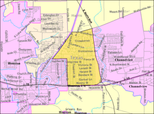
Cloverleaf is a census-designated place (CDP) in east central Harris County, Texas, United States. The population was 24,100 at the 2020 census.
Contents
History
Cloverleaf originated as a stop on the Beaumont, Sour Lake, and Western Railway. A 1936 county highway map indicates an unnamed development that became Cloverleaf. The Handbook of Texas states that a post office may have existed for a short period of time around 1950. In 1990, Cloverleaf had 18,230 residents and 18 churches.
Geography
Cloverleaf is located at 29°47′5″N 95°10′23″W / 29.78472°N 95.17306°W (29.784676, -95.172959). The community is located between the city of Jacinto City and the Channelview CDP along Interstate 10.
According to the United States Census Bureau, the CDP has a total area of 3.3 square miles (8.6 km2), all land.
Demographics
| Historical population | |||
|---|---|---|---|
| Census | Pop. | %± | |
| 1980 | 17,317 | — | |
| 1990 | 18,230 | 5.3% | |
| 2000 | 23,508 | 29.0% | |
| 2010 | 22,942 | −2.4% | |
| 2020 | 24,100 | 5.0% | |
| U.S. Decennial Census 1850–1900 1910 1920 1930 1940 1950 1960 1970 1980 1990 2000 2010 |
|||
2020 census
| Race | Number | Percentage |
|---|---|---|
| White (NH) | 2,829 | 11.74% |
| Black or African American (NH) | 2,132 | 8.85% |
| Native American or Alaska Native (NH) | 40 | 0.17% |
| Asian (NH) | 220 | 0.91% |
| Pacific Islander (NH) | 3 | 0.01% |
| Some Other Race (NH) | 44 | 0.18% |
| Mixed/Multi-Racial (NH) | 228 | 0.95% |
| Hispanic or Latino | 18,604 | 77.2% |
| Total | 24,100 |
As of the 2020 United States census, there were 24,100 people, 7,087 households, and 5,743 families residing in the CDP. At the 2000 census there were 23,508 people, 7,287 households, and 5,800 families in the CDP. The population density was 6,589.2 inhabitants per square mile (2,544.1/km2). There were 7,865 housing units at an average density of 2,204.5 per square mile (851.2/km2).
In 2000, the racial makup of the CDP was 58.77% White, 16.11% African American, 0.59% Native American, 1.51% Asian, 0.05% Pacific Islander, 20.27% from other races, and 2.71% from two or more races. Hispanic or Latino of any race were 44.34%. By 2020, non-Hispanic whites declined to 11.74% of the population, and Hispanics or Latinos of any race grew to 77.2% of the population.
In 2000, the median household income was $37,449 and the median family income was $40,231. Males had a median income of $30,958 versus $25,044 for females. The per capita income for the CDP was $16,245. About 15.6% of families and 20.3% of the population were below the poverty line, including 26.8% of those under age 18 and 4.9% of those age 65 or over. In 2020, the median household income increased to $49,276.
Education
Cloverleaf is zoned to schools in the Galena Park Independent School District.
Elementary schools in the Cloverleaf CDP include Cloverleaf Elementary School, Green Valley Elementary School, Havard Elementary School, Sam Houston Elementary School, and North Shore Elementary School. All residents are zoned to Cobb 6th Grade School, which is located outside the CDP. Most residents are zoned to North Shore Middle School, in the CDP, for grades 7 through 8; some residents are zoned to Cunningham Middle School, outside the CDP, instead. All residents are zoned to North Shore Senior High School for grades 9 through 12.
In 1990, Cloverleaf had two elementary schools, one junior high school, and one high school.
Residents of Galena Park ISD (and therefore Cloverleaf CDP) are zoned to San Jacinto College.
See also
 In Spanish: Cloverleaf para niños


