Christopher Creek, Arizona facts for kids
Quick facts for kids
Christopher Creek, Arizona
|
|
|---|---|
 |
|

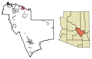
Location of Christopher Creek in Gila County, Arizona.
|
|
| Country | |
| State | |
| County | Gila |
| Area | |
| • Total | 3.14 sq mi (8.13 km2) |
| • Land | 3.14 sq mi (8.13 km2) |
| • Water | 0.00 sq mi (0.00 km2) |
| Elevation | 5,961 ft (1,817 m) |
| Population
(2020)
|
|
| • Total | 121 |
| • Density | 38.55/sq mi (14.88/km2) |
| Time zone | UTC−7 (MST) |
| • Summer (DST) | UTC−7 (no DST/PDT) |
| ZIP code |
85541
|
| Area code(s) | 928 |
| FIPS code | 04-13140 |
| GNIS ID(s) | 2582755 |
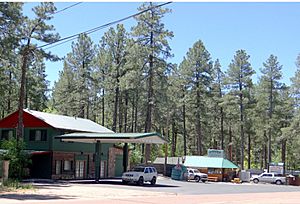
Christopher Creek is a census-designated place in northern Gila County in the U.S. state of Arizona. Situated at the base of the Mogollon Rim, the community lies at an elevation of 5,961 feet (1,817 m), and is located approximately 23.5 miles (37.82 km) northeast of Payson, just off SR 260. The population as of the 2010 U.S. Census was 156.
Tourism, retirement and timbering are the foundations of Christopher Creek's economy.
Demographics
| Historical population | |||
|---|---|---|---|
| Census | Pop. | %± | |
| 2020 | 121 | — | |
| U.S. Decennial Census | |||
Transportation
Mountain Valley Shuttle stops in Christopher Creek on its Phoenix-Show Low route.
See also
 In Spanish: Christopher Creek para niños

All content from Kiddle encyclopedia articles (including the article images and facts) can be freely used under Attribution-ShareAlike license, unless stated otherwise. Cite this article:
Christopher Creek, Arizona Facts for Kids. Kiddle Encyclopedia.


