Chippewa County, Wisconsin facts for kids
Quick facts for kids
Chippewa County
|
|
|---|---|

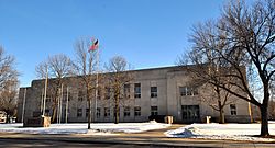
Chippewa County Courthouse, February 2015
|
|

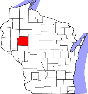
Location within the U.S. state of Wisconsin
|
|
 Wisconsin's location within the U.S. |
|
| Country | |
| State | |
| Founded | 1853 |
| Named for | Ojibwa |
| Seat | Chippewa Falls |
| Largest city | Chippewa Falls |
| Area | |
| • Total | 1,041 sq mi (2,700 km2) |
| • Land | 1,008 sq mi (2,610 km2) |
| • Water | 33 sq mi (90 km2) 3.2% |
| Population
(2020)
|
|
| • Total | 66,297 |
| • Estimate
(2023)
|
66,970 |
| • Density | 65.7/sq mi (25.4/km2) |
| Time zone | UTC−6 (Central) |
| • Summer (DST) | UTC−5 (CDT) |
| Congressional districts | 3rd, 7th |
Chippewa County (![]() i/ˈtʃɪpəwɔː/) is a county located in the U.S. state of Wisconsin. It is named for the historic Chippewa people, also known as the Ojibwe, who long controlled this territory. As of the 2020 census, the population was 66,297. Its county seat is Chippewa Falls. The county was founded in 1845 from Crawford County, then in the Wisconsin Territory, and organized in 1853.
i/ˈtʃɪpəwɔː/) is a county located in the U.S. state of Wisconsin. It is named for the historic Chippewa people, also known as the Ojibwe, who long controlled this territory. As of the 2020 census, the population was 66,297. Its county seat is Chippewa Falls. The county was founded in 1845 from Crawford County, then in the Wisconsin Territory, and organized in 1853.
Chippewa County is included in the Eau Claire, WI Metropolitan Statistical Area as well as the Eau Claire-Menomonie, WI Combined Statistical Area.
Contents
Geography
According to the U.S. Census Bureau, the county has a total area of 1,041 square miles (2,700 km2), of which 1,008 square miles (2,610 km2) is land and 33 square miles (85 km2) (3.2%) is water.
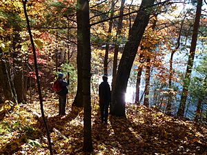
Parts of northern Chippewa county are covered with choppy hills dimpled by kettle lakes and bogs—the terminal moraine left by the last glacier. The Ice Age Trail threads through some of this country, providing public foot-access to these unusual landforms.
Adjacent counties
- Rusk County – north
- Taylor County – east
- Clark County – southeast
- Eau Claire County – south
- Dunn County – west
- Barron County – northwest
Major highways
Railroads
- Union Pacific
- Wisconsin Northern Railroad
- Canadian National
Buses
- Eau Claire Transit
Airports
- KEAU - Chippewa Valley Regional Airport
- 4WI9 - Cornell Municipal Airport
Demographics
| Historical population | |||
|---|---|---|---|
| Census | Pop. | %± | |
| 1850 | 615 | — | |
| 1860 | 1,895 | 208.1% | |
| 1870 | 8,311 | 338.6% | |
| 1880 | 15,491 | 86.4% | |
| 1890 | 25,143 | 62.3% | |
| 1900 | 33,037 | 31.4% | |
| 1910 | 32,103 | −2.8% | |
| 1920 | 36,482 | 13.6% | |
| 1930 | 37,342 | 2.4% | |
| 1940 | 40,703 | 9.0% | |
| 1950 | 42,839 | 5.2% | |
| 1960 | 45,096 | 5.3% | |
| 1970 | 47,717 | 5.8% | |
| 1980 | 52,127 | 9.2% | |
| 1990 | 52,360 | 0.4% | |
| 2000 | 55,195 | 5.4% | |
| 2010 | 62,415 | 13.1% | |
| 2020 | 66,297 | 6.2% | |
| U.S. Decennial Census 1790–1960 1900–1990 1990–2000 2010 2020 |
|||
2020 census
As of the census of 2020, the population was 66,297. The population density was 65.7 people per square mile (25.4 people/km2). There were 28,688 housing units at an average density of 28.5 units per square mile (11.0 units/km2). The racial makeup of the county was 91.8% White, 1.6% Black or African American, 1.5% Asian, 0.5% Native American, 0.6% from other races, and 4.0% from two or more races. Ethnically, the population was 1.9% Hispanic or Latino of any race.
Economy
The largest employers in Chippewa County are:
| 1 | TTM Advanced Circuits |
| 2 | Chippewa Falls Public Schools |
| 3 | Saint Joseph's Hospital |
| 4 | Wisconsin Department of Corrections |
| 5 | Wal-Mart |
| 6 | Mason Companies Inc |
| 7 | Chippewa County |
| 8 | Mayo Health System |
| 9 | Silicon Graphics International |
| 10 | Cooperative Educational Service Agency #10 |
Library
The University of Wisconsin-Eau Claire's Special Collections and Archives, located on the fifth floor of McIntyre Library, houses an extensive collection of public records, books and collections relating to Chippewa County. In addition to vital records (birth and marriage) dating to 1907, there are also naturalization records, census records, and civil and circuit court records. These resources are very popular with local genealogists.
Within the local history collection, there are books about immigration to the region, logging, church and cemetery records, reminiscences by local residents, and a number of histories and biographies compiled by local historians.
Special Collections and Archives also houses numerous archives files which relate to Chippewa County. There are many collections which pertain to logging, the railway industry and agriculture.
The University of Wisconsin-Eau Claire's Special Collections and Archives also includes information for Buffalo, Clark, Eau Claire, Rusk and Taylor counties.
Communities
Cities
- Bloomer
- Chippewa Falls (county seat)
- Cornell
- Eau Claire (mostly in Eau Claire County)
- Stanley (partly in Clark County)
Villages
- Boyd
- Cadott
- Lake Hallie
- New Auburn (partly in Barron County)
Towns
Census-designated places
Other unincorporated communities
See also
 In Spanish: Condado de Chippewa (Wisconsin) para niños


