Cherry Grove, Alberta facts for kids
Quick facts for kids
Cherry Grove
|
|
|---|---|
|
Hamlet
|
|
| Country | Canada |
| Province | Alberta |
| Region | Central Alberta |
| Census division | 12 |
| Municipal district | M.D. of Bonnyville No. 87 |
| Elevation | 550 m (1,800 ft) |
| Population
(2014)
|
|
| • Total | 405 |
| Time zone | UTC−7 (MST) |
| • Summer (DST) | UTC−6 (MDT) |
| Postal code span |
T0A 0T0
|
| Area code(s) | 780 |
| NTS Map | 073L08 |
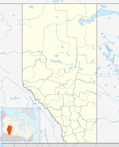
Cherry Grove is a hamlet in central Alberta, Canada within the Municipal District of Bonnyville No. 87. It is 1 km (0.62 mi) north of Highway 55, approximately 12 km (7.5 mi) southeast of Cold Lake.
Demographics
The population of Cherry Grove according to the 2014 municipal census conducted by the Municipal District of Bonnyville No. 87 is 405.
Black History Month on Kiddle
Famous African-American Architects:
 | Georgia Louise Harris Brown |
 | Julian Abele |
 | Norma Merrick Sklarek |
 | William Sidney Pittman |

All content from Kiddle encyclopedia articles (including the article images and facts) can be freely used under Attribution-ShareAlike license, unless stated otherwise. Cite this article:
Cherry Grove, Alberta Facts for Kids. Kiddle Encyclopedia.

