Cherhill, Alberta facts for kids
Quick facts for kids
Cherhill
|
|
|---|---|

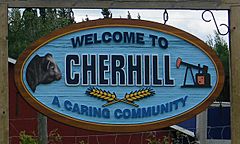
An entrance sign of Cherhill
|
|
| Country | Canada |
| Province | Alberta |
| Census division | No. 13 |
| Municipal district | Lac Ste. Anne County |
| First post office | 1911 |
| Government | |
| • Type | Unincorporated |
| Population
(2008)
|
|
| • Total | 60 |
| Time zone | UTC−7 (MST) |
| • Summer (DST) | UTC−6 (MDT) |
Cherhill is a hamlet in Alberta, Canada within Lac Ste. Anne County. It is located along Highway 43, approximately 35 kilometres (22 mi) east of Mayerthorpe and 82 kilometres (51 mi) northwest of Edmonton.
The hamlet is located in census division No. 13.
The first syllable of the Cherhill's name is derived from the last syllable of the name of A. P. Stetcher, the postmaster when the post office opened in 1911, with "hill" added to it.
Demographics
As of a 2008 census conducted by Lac Ste. Anne County, the population of Cherhill was 60.

All content from Kiddle encyclopedia articles (including the article images and facts) can be freely used under Attribution-ShareAlike license, unless stated otherwise. Cite this article:
Cherhill, Alberta Facts for Kids. Kiddle Encyclopedia.

