Carry Falls Reservoir facts for kids
Quick facts for kids Carry Falls Reservoir |
|
|---|---|
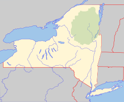
| Location | St. Lawrence County, New York, United States |
| Coordinates | 44°24′25″N 74°43′59″W / 44.4070379°N 74.7329530°W, 44°25′02″N 74°45′32″W / 44.4172716°N 74.7588728°W, 44°21′21″N 74°43′25″W / 44.3558912°N 74.7235455°W |
| Type | Reservoir |
| Primary inflows | Raquette River, Brandy Brook, Cold Brook, Little Cold Brook, Jordan River, Felton Brook |
| Primary outflows | Raquette River |
| Basin countries | United States |
| Surface area | 3,074 acres (12.44 km2) |
| Average depth | 18 feet (5.5 m) |
| Max. depth | 50 feet (15 m) |
| Shore length1 | 29 miles (47 km) |
| Surface elevation | 1,384 feet (422 m) |
| Islands | 5 Radio Island, Maple Island |
| Settlements | Stark, New York |
| 1 Shore length is not a well-defined measure. | |
Carry Falls Reservoir is a man-made lake located by Stark, New York. Fish species present in the reservoir are smallmouth bass, northern pike, yellow perch, black bullhead, tiger muskellunge, rock bass, and walleye. There is a state owned hard ramp boat launch located on the southwest shore.

All content from Kiddle encyclopedia articles (including the article images and facts) can be freely used under Attribution-ShareAlike license, unless stated otherwise. Cite this article:
Carry Falls Reservoir Facts for Kids. Kiddle Encyclopedia.


