Carepa facts for kids
Quick facts for kids
Carepa
|
|||
|---|---|---|---|
|
Municipality and town
|
|||
|
|||

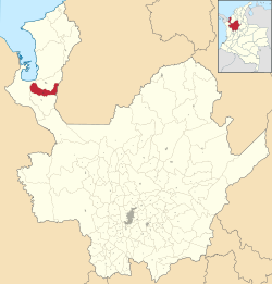
Location of the municipality and town of Carepa in the Antioquia Department of Colombia
|
|||
| Country | |||
| Department | |||
| Subregion | Urabá | ||
| Area | |||
| • Municipality and town | 387.3 km2 (149.5 sq mi) | ||
| • Urban | 2.6 km2 (1.0 sq mi) | ||
| Population
(2018 census)
|
|||
| • Municipality and town | 47,932 | ||
| • Density | 123.759/km2 (320.54/sq mi) | ||
| • Urban | 33,009 | ||
| • Urban density | 12,700/km2 (32,900/sq mi) | ||
| Time zone | UTC-5 (Colombia Standard Time) | ||
Carepa is a town and municipality in Antioquia Department, Colombia. Carepa is part of the Urabá Antioquia sub-region.
Climate
Carepa has a tropical rainforest climate (Af) with heavy to very heavy rainfall year-round.
| Climate data for Carepa (Tulenapa), elevation 30 m (98 ft), (1981–2010) | |||||||||||||
|---|---|---|---|---|---|---|---|---|---|---|---|---|---|
| Month | Jan | Feb | Mar | Apr | May | Jun | Jul | Aug | Sep | Oct | Nov | Dec | Year |
| Mean daily maximum °C (°F) | 30.7 (87.3) |
30.7 (87.3) |
31.0 (87.8) |
31.2 (88.2) |
31.3 (88.3) |
31.3 (88.3) |
31.3 (88.3) |
31.4 (88.5) |
31.3 (88.3) |
31.1 (88.0) |
30.9 (87.6) |
30.8 (87.4) |
31.1 (88.0) |
| Daily mean °C (°F) | 26.7 (80.1) |
26.8 (80.2) |
27.0 (80.6) |
27.2 (81.0) |
27.0 (80.6) |
26.9 (80.4) |
26.7 (80.1) |
26.8 (80.2) |
26.7 (80.1) |
26.6 (79.9) |
26.5 (79.7) |
26.6 (79.9) |
26.8 (80.2) |
| Mean daily minimum °C (°F) | 23.3 (73.9) |
23.3 (73.9) |
23.5 (74.3) |
23.9 (75.0) |
23.8 (74.8) |
23.4 (74.1) |
23.2 (73.8) |
23.5 (74.3) |
23.3 (73.9) |
23.3 (73.9) |
23.2 (73.8) |
23.2 (73.8) |
23.4 (74.1) |
| Average precipitation mm (inches) | 92.7 (3.65) |
76.5 (3.01) |
98.8 (3.89) |
248.1 (9.77) |
320.9 (12.63) |
316.3 (12.45) |
284.0 (11.18) |
277.5 (10.93) |
319.2 (12.57) |
319.7 (12.59) |
307.1 (12.09) |
214.0 (8.43) |
2,872 (113.1) |
| Average precipitation days (≥ 1.0 mm) | 9 | 7 | 10 | 16 | 21 | 22 | 21 | 22 | 21 | 21 | 19 | 14 | 197 |
| Average relative humidity (%) | 85 | 85 | 84 | 86 | 88 | 89 | 88 | 88 | 87 | 87 | 88 | 88 | 87 |
| Mean monthly sunshine hours | 182.9 | 152.4 | 136.4 | 120.0 | 130.2 | 126.0 | 148.8 | 148.8 | 135.0 | 151.9 | 150.0 | 161.2 | 1,743.6 |
| Mean daily sunshine hours | 5.9 | 5.4 | 4.4 | 4.0 | 4.2 | 4.2 | 4.8 | 4.8 | 4.5 | 4.9 | 5.0 | 5.2 | 4.8 |
| Source: Instituto de Hidrologia Meteorologia y Estudios Ambientales | |||||||||||||
| Climate data for Carepa (Antonio Roldán Betancur Airport), elevation 19 m (62 ft), (1981–2010) | |||||||||||||
|---|---|---|---|---|---|---|---|---|---|---|---|---|---|
| Month | Jan | Feb | Mar | Apr | May | Jun | Jul | Aug | Sep | Oct | Nov | Dec | Year |
| Mean daily maximum °C (°F) | 30.6 (87.1) |
30.6 (87.1) |
30.8 (87.4) |
31.1 (88.0) |
31.5 (88.7) |
31.5 (88.7) |
31.5 (88.7) |
31.7 (89.1) |
31.7 (89.1) |
31.5 (88.7) |
31.2 (88.2) |
30.9 (87.6) |
31.2 (88.2) |
| Daily mean °C (°F) | 27.1 (80.8) |
27.1 (80.8) |
27.3 (81.1) |
27.5 (81.5) |
27.5 (81.5) |
27.5 (81.5) |
27.5 (81.5) |
27.5 (81.5) |
27.3 (81.1) |
27.2 (81.0) |
27.1 (80.8) |
27.1 (80.8) |
27.3 (81.1) |
| Mean daily minimum °C (°F) | 23.4 (74.1) |
23.6 (74.5) |
23.7 (74.7) |
23.9 (75.0) |
23.6 (74.5) |
23.4 (74.1) |
23.1 (73.6) |
23.1 (73.6) |
22.9 (73.2) |
23.0 (73.4) |
22.9 (73.2) |
23.3 (73.9) |
23.3 (73.9) |
| Average precipitation mm (inches) | 110.8 (4.36) |
99.7 (3.93) |
156.1 (6.15) |
285.3 (11.23) |
379.4 (14.94) |
342.7 (13.49) |
348.0 (13.70) |
291.2 (11.46) |
330.0 (12.99) |
347.7 (13.69) |
332.3 (13.08) |
250.2 (9.85) |
3,273.4 (128.87) |
| Average precipitation days (≥ 1.0 mm) | 10 | 10 | 13 | 19 | 23 | 23 | 23 | 23 | 22 | 22 | 19 | 16 | 222 |
| Average relative humidity (%) | 82 | 82 | 82 | 83 | 84 | 84 | 83 | 83 | 83 | 83 | 84 | 83 | 83 |
| Mean monthly sunshine hours | 179.8 | 152.4 | 142.6 | 126.0 | 120.9 | 114.0 | 130.2 | 136.4 | 129.0 | 145.7 | 141.0 | 145.7 | 1,663.7 |
| Mean daily sunshine hours | 5.8 | 5.4 | 4.6 | 4.2 | 3.9 | 3.8 | 4.2 | 4.4 | 4.3 | 4.7 | 4.7 | 4.7 | 4.6 |
| Source: Instituto de Hidrologia Meteorologia y Estudios Ambientales | |||||||||||||
Notable people
- Lina Flórez (1984-), athlete
- Hermán Gaviria (1969-2002), Football player
- Andrés Mosquera Marmolejo, football player
See also
 In Spanish: Carepa para niños

All content from Kiddle encyclopedia articles (including the article images and facts) can be freely used under Attribution-ShareAlike license, unless stated otherwise. Cite this article:
Carepa Facts for Kids. Kiddle Encyclopedia.


