
Cape Schanck, Victoria facts for kids
Quick facts for kids Cape SchanckVictoria |
|||||||||
|---|---|---|---|---|---|---|---|---|---|
.JPG)
Cape Schanck (view from atop the lighthouse)
|
|||||||||
| Population | 334 (2006) | ||||||||
| Postcode(s) | 3939 | ||||||||
| Elevation | 79 m (259 ft) | ||||||||
| Location |
|
||||||||
| LGA(s) | Shire of Mornington Peninsula | ||||||||
| State electorate(s) | Nepean | ||||||||
| Federal Division(s) | Flinders | ||||||||
|
|||||||||

Cape Schanck is the south end of the Mornington Peninsula, Victoria, Australia. It is a piece of land that separates Port Phillip Bay and Westernport Bay. It is a narrow headland with cliffs 84.7 metres (278 feet) high. It has a lighthouse made from limestone built in 1859. In December 1800, Cape Schanck was named by Lieutenant James Grant after Admiral James Schank.
Images for kids
-
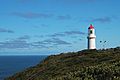
Cape Schanck Lighthouse
-
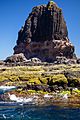
Pulpit Rock


All content from Kiddle encyclopedia articles (including the article images and facts) can be freely used under Attribution-ShareAlike license, unless stated otherwise. Cite this article:
Cape Schanck, Victoria Facts for Kids. Kiddle Encyclopedia.