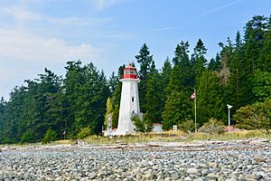
Cape Mudge Lighthouse facts for kids
 |
|
| Cape Mudge Lighthouse | |
|
|
|
| Location | Quadra Island British Columbia Canada |
|---|---|
| Coordinates | 49°59′54.8″N 125°11′43.9″W / 49.998556°N 125.195528°W |
| Year first constructed | 1898 (first) |
| Year first lit | 1916 (current) |
| Construction | concrete tower |
| Tower shape | octagonal tower with balcony and lantern |
| Markings / pattern | white tower, red balcony and lantern |
| Height | 12 metres (39 ft) |
| Focal height | 17.5 metres (57 ft) |
| Characteristic | F WR |
| Admiralty number | G5580 |
| CHS number | CCG 0511 |
| NGA number | 12560 |
| ARLHS number | CAN-100 |
Cape Mudge Lighthouse is located on Quadra Island which is off Campbell River, on the east coast of Vancouver Island, British Columbia, Canada.
Cape Mudge was named by Captain Vancouver in 1792 after Zachary Mudge who served on HMS Discovery, and in 1796 on HMS Providence in this area.
From 1936 to 1985, the Cape Mudge Lighthouse was part of the British Columbia Shore Station Oceanographic Program, collecting coastal water temperature and salinity measurements for the Department of Fisheries and Oceans everyday for 49 years.

All content from Kiddle encyclopedia articles (including the article images and facts) can be freely used under Attribution-ShareAlike license, unless stated otherwise. Cite this article:
Cape Mudge Lighthouse Facts for Kids. Kiddle Encyclopedia.

