Cantel, Guatemala facts for kids
Quick facts for kids
Cantel
|
|
|---|---|
|
Municipality and town
|
|

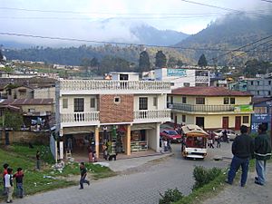
Cantel from the Quetzaltenango - Retalhueu highway
|
|
| Country | |
| Department | |
| Area | |
| • Total | 20.3 sq mi (52.6 km2) |
| Population
(2018 census)
|
|
| • Total | 42,142 |
| • Density | 2,075.0/sq mi (801.2/km2) |
| Time zone | UTC+6 (Central Time) |
| Climate | Cwb |
Cantel is a municipality in the Quetzaltenango Department in Guatemala. It is located 7 miles east of the city of Quetzaltenango and has an area of 52.6 km2. The town of Cantel has a population of 47,941 (2023 census), and is situated at an altitude of 2,370 metres.
Cantel includes the small Maya archaeological sites of Chojolom and Cerro Quiac.
See also
 In Spanish: Cantel para niños

All content from Kiddle encyclopedia articles (including the article images and facts) can be freely used under Attribution-ShareAlike license, unless stated otherwise. Cite this article:
Cantel, Guatemala Facts for Kids. Kiddle Encyclopedia.

