Candelero Abajo facts for kids
Quick facts for kids
Candelero Abajo
|
|
|---|---|
|
Barrio
|
|

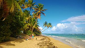
Punta Candelero in Candelero Abajo
|
|

Location of Candelero Abajo within the municipality of Humacao shown in red
|
|
| Commonwealth | |
| Municipality | |
| Area | |
| • Total | 5.80 sq mi (15.0 km2) |
| • Land | 4.83 sq mi (12.5 km2) |
| • Water | 0.97 sq mi (2.5 km2) |
| Elevation | 95 ft (29 m) |
| Population
(2010)
|
|
| • Total | 5,135 |
| • Density | 1,054.4/sq mi (407.1/km2) |
| Source: 2010 Census | |
| Time zone | UTC−4 (AST) |
| ZIP Code |
00791
|
Candelero Abajo is a barrio in the municipality of Humacao, Puerto Rico. Its population in 2010 was 5,135.
Contents
History
Puerto Rico was ceded by Spain in the aftermath of the Spanish–American War under the terms of the Treaty of Paris of 1898 and became an unincorporated territory of the United States. In 1899, the United States Department of War conducted a census of Puerto Rico finding that the population of Candelero Abajo barrio was 972.
| Historical population | |||
|---|---|---|---|
| Census | Pop. | %± | |
| 1900 | 972 | — | |
| 1980 | 1,907 | — | |
| 1990 | 2,825 | 48.1% | |
| 2000 | 3,365 | 19.1% | |
| 2010 | 5,135 | 52.6% | |
| U.S. Decennial Census 1899 (shown as 1900) 1910-1930 1930-1950 1980-2000 2010 |
|||
Flood zone
In 2019, updated flood zone maps show that because of its location- where most cyclones enter the island, Humacao is one of the most vulnerable areas of Puerto Rico. Humacao was working on flood mitigation plans and shared that its barrios located on the coast; Antón Ruíz, Punta Santiago, Río Abajo, Buena Vista and Candelero Abajo barrios, are prone to flooding and in danger of being completed destroyed by a hurricane.
Gallery
See also
 In Spanish: Candelero Abajo para niños
- List of communities in Puerto Rico


