Canadian Shield facts for kids
Quick facts for kids Canadian ShieldStratigraphic range: Precambrian 4500–540 mya |
|
|---|---|
| Type | Shield |
| Unit of | North American craton |
| Sub-units | Laurentian Upland Kazan |
| Area | 8 000 000 km2 |
| Location | |
| Region | North America |
| Country | |
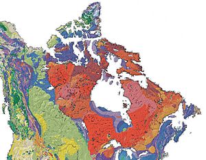
 The Canadian Shield is a broad region of Precambrian rock (pictured in shades of red) that encircles Hudson Bay. It spans eastern, northeastern, and east-central Canada and the upper midwestern United States. |
|
The Canadian Shield is also called the Laurentian Plateau, or Bouclier canadien (French).
The Canadian Shield is a vast geological region characterized by exposed Precambrian rock, making it one of the largest and oldest continental shields in the world. It is the ancient geological core of the North American continent (the North American Craton or Laurentia).
A continuation of the shield is in west Greenland, to which it was once connected. In the United States the shield is mostly covered with much younger rocks and sediment.
The Canadian Shield round Hudson Bay is covered with shallow soil. Its main industrial use is for mining.
Contents
Size and shape
The Canadian Shield constitutes the largest mass of exposed Precambrian rock on Earth, with some formations dating back over 4 billion years. It is primarily composed of ancient crystalline rocks, including igneous and high-grade metamorphic rocks.
The Shield covers approximately 8 million square kilometers (3 million square miles), spanning eastern and central Canada, including parts of Quebec, Ontario, Manitoba, Saskatchewan, Alberta, the Northwest Territories, Nunavut, and extending into parts of the United States such as Minnesota, Wisconsin, and New York.
The region is often described as shaped like a horseshoe or shield, encircling Hudson Bay.
Physical Characteristics
The landscape consists of rocky hills and irregular basins filled with lakes and swamps. The average elevation is between 300 to 610 meters (980 to 2,000 feet) above sea level.
During the Pleistocene Epoch, glaciers shaped much of the Canadian Shield's current topography by scraping away soil and weathered rock, resulting in its characteristic bare rock surfaces and thin soils.
Natural Resources
The Canadian Shield is rich in minerals such as gold, silver, copper, zinc, uranium, and iron. Mining has become a significant industry in this region due to the accessibility of these resources.
The numerous lakes and rivers within the Shield provide substantial opportunities for hydroelectric power generation. Major hydroelectric projects include those at Churchill Falls in Labrador and James Bay in Quebec.
Ecology
The Shield primarily features boreal forests dominated by coniferous trees. As one moves northward, the vegetation transitions into tundra ecosystems due to colder temperatures.
Human History
The Canadian Shield has been home to various Indigenous groups for thousands of years. Tribes such as the Cree, Anishinaabeg, Innu, Dene, and Inuit have historically inhabited this region.
European settlers recognized the area's potential for fur trading due to its abundant wildlife. The waterways facilitated travel and trade among Indigenous peoples and later European explorers. The Canadian Shield remains a vital part of Canada's geography and economy due to its natural resources and ecological significance.
Images for kids
-
Folded Precambrian gneiss of the Canadian Shield in Georgian Bay, Ontario
See also
 In Spanish: Escudo Canadiense para niños


