Camp County, Texas facts for kids
Quick facts for kids
Camp County
|
|
|---|---|

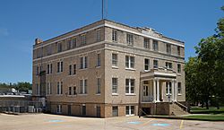
Camp County Courthouse in Pittsburg
|
|

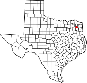
Location within the U.S. state of Texas
|
|
 Texas's location within the U.S. |
|
| Country | |
| State | |
| Founded | 1874 |
| Named for | John Lafayette Camp |
| Seat | Pittsburg |
| Largest city | Pittsburg |
| Area | |
| • Total | 203 sq mi (530 km2) |
| • Land | 196 sq mi (510 km2) |
| • Water | 7.4 sq mi (19 km2) 3.6% |
| Population
(2020)
|
|
| • Total | 12,464 |
| • Density | 61.40/sq mi (23.71/km2) |
| Time zone | UTC−6 (Central) |
| • Summer (DST) | UTC−5 (CDT) |
| Congressional district | 1st |
Camp County is a county in the eastern part of Texas. As of the 2020 census, its population was 12,464. Its seat is Pittsburg. The county was founded in 1874 and is named for John Lafayette Camp, a Texas politician.
Contents
Geography
According to the U.S. Census Bureau, the county has a total area of 203 square miles (530 km2), of which 7.4 square miles (19 km2) (3.6%) are covered by water. It is the third smallest county by area in Texas.
Major highways
Adjacent counties
- Titus County (north)
- Morris County (east)
- Upshur County (south)
- Wood County (southwest)
- Franklin County (west)
Communities
City
- Pittsburg (county seat)
Town
Unincorporated communities
- Center Point
- Ebenezer
- Harvard
- Leesburg
- Newsome
- Pine
Ghost town
- Crossroads
- Holly Springs
- Matinburg
Demographics
| Historical population | |||
|---|---|---|---|
| Census | Pop. | %± | |
| 1880 | 5,951 | — | |
| 1890 | 6,624 | 11.3% | |
| 1900 | 9,146 | 38.1% | |
| 1910 | 9,551 | 4.4% | |
| 1920 | 11,103 | 16.2% | |
| 1930 | 10,063 | −9.4% | |
| 1940 | 10,285 | 2.2% | |
| 1950 | 8,740 | −15.0% | |
| 1960 | 7,849 | −10.2% | |
| 1970 | 8,005 | 2.0% | |
| 1980 | 9,275 | 15.9% | |
| 1990 | 9,904 | 6.8% | |
| 2000 | 11,549 | 16.6% | |
| 2010 | 12,401 | 7.4% | |
| 2020 | 12,464 | 0.5% | |
| U.S. Decennial Census 1850–2010 2010–2020 |
|||
| Race / Ethnicity (NH = Non-Hispanic) | Pop 2000 | Pop 2010 | Pop 2020 | % 2000 | % 2010 | % 2020 |
|---|---|---|---|---|---|---|
| White alone (NH) | 7,507 | 7,298 | 6,734 | 65.00% | 58.85% | 54.03% |
| Black or African American alone (NH) | 2,201 | 2,133 | 1,877 | 19.06% | 17.20% | 15.06% |
| Native American or Alaska Native alone (NH) | 25 | 38 | 28 | 0.22% | 0.31% | 0.22% |
| Asian alone (NH) | 19 | 59 | 105 | 0.16% | 0.48% | 0.84% |
| Pacific Islander alone (NH) | 5 | 17 | 8 | 0.04% | 0.14% | 0.06% |
| Other race alone (NH) | 6 | 4 | 34 | 0.05% | 0.03% | 0.27% |
| Mixed race or Multiracial (NH) | 79 | 204 | 456 | 0.68% | 1.65% | 3.66% |
| Hispanic or Latino (any race) | 1,707 | 2,648 | 3,222 | 14.78% | 21.35% | 25.85% |
| Total | 11,549 | 12,401 | 12,464 | 100.00% | 100.00% | 100.00% |
According to the census of 2000, 11,549 people, 4,336 households, and 3,156 families were living in the county. The population density was 58 people per square mile (22 people/km2). The 5,228 housing units had an average density of 26 per square mile (10/km2). The racial makeup of the county was 69.53% White, 19.20% African American, 0.35% Native American, 0.17% Asian, 9.68% from other races, and 1.07% from two or more races; 14.78% of the population were Hispanics or Latinos of any race.
Up from 2000's population of 11,549 people, and 2010's 12,401 residents, Camp County grew to 12,464 at the 2020 U.S. census. Among the 2020 population, its racial and ethnic makeup was 54.03% non-Hispanic White, 15.06% Black or African American, 0.22% Native American, 0.84% Asian, 0.06% Pacific Islander, 0.27% some other race, 3.66% multiracial, and 25.85% Hispanic or Latino of any race. Like the majority of the United States at the time, these represented the demographic trends as the U.S. experienced great diversification.
See also
 In Spanish: Condado de Camp para niños

