Cactus Forest, Arizona facts for kids
Quick facts for kids
Cactus Forest, Arizona
|
|
|---|---|

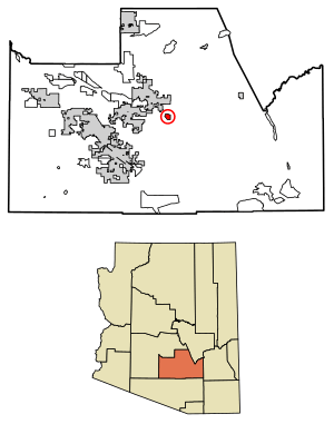
Location of Cactus Forest in Pinal County, Arizona.
|
|
| Country | United States |
| State | Arizona |
| County | Pinal |
| Area | |
| • Total | 2.73 sq mi (7.08 km2) |
| • Land | 2.73 sq mi (7.08 km2) |
| • Water | 0.00 sq mi (0.00 km2) |
| Population
(2020)
|
|
| • Total | 606 |
| • Density | 221.82/sq mi (85.64/km2) |
| Time zone | UTC-7 (MST (no DST)) |
| ZIP code |
85132
|
| Area code(s) | 520 |
| FIPS code | 04-08990 |
Cactus Forest is a census-designated place (CDP) in Pinal County, Arizona, United States. The population was 594 at the 2010 census.
Demographics
| Historical population | |||
|---|---|---|---|
| Census | Pop. | %± | |
| 2010 | 594 | — | |
| 2020 | 606 | 2.0% | |
| U.S. Decennial Census | |||
Cactus Forest first appeared on the 2010 U.S. Census as a census-designated place (CDP).
As of the census of 2010, there were 594 people living in the CDP. The population density was 217.4 people per square mile. The racial makeup of the CDP was 87% White, 2% Black or African American, 4% Native American, <1% Asian, 5% from other races, and 3% from two or more races. 21% of the population were Hispanic or Latino of any race.
See also
 In Spanish: Cactus Forest para niños

All content from Kiddle encyclopedia articles (including the article images and facts) can be freely used under Attribution-ShareAlike license, unless stated otherwise. Cite this article:
Cactus Forest, Arizona Facts for Kids. Kiddle Encyclopedia.

