Cabramurra, New South Wales facts for kids
Quick facts for kids CabramurraNew South Wales |
|||||||||
|---|---|---|---|---|---|---|---|---|---|

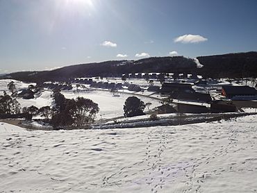
Cabramurra town, afternoon in winter, looking north from the lookout
|
|||||||||
| Population | 37 (2016 census) | ||||||||
| Established | 1954 | ||||||||
| Postcode(s) | 2629 | ||||||||
| Elevation | 1,488 m (4,882 ft) | ||||||||
| Location | |||||||||
| LGA(s) | Snowy Valleys Shire | ||||||||
| State electorate(s) | Albury | ||||||||
| Federal Division(s) | Eden-Monaro | ||||||||
|
|||||||||
Cabramurra is a town situated at 1,488 metres (4,882 ft) on the western side of the Snowy Mountains (or South West Slopes), along the Great Dividing Range in the state of New South Wales. It is 82 metres (269 ft) lower than Dinner Plain in Victoria, and 272 metres (892 ft) lower than Charlotte Pass Village in New South Wales. From the 1950s until 2018 it had a resident population, serving the Snowy Hydro scheme, including facilities such as pubs, general store and a primary school. However, this ended with the switch to contractors operating on a drive-in/drive-out basis. The name Cabramurra may be derived from Wiradjuri gambirra marra ("crooked hand").
Contents
History
Cabramurra was established in 1954 using prefabricated houses, as part of the Snowy Mountains Scheme and associated Snowy Mountains Hydro-Electric Scheme. An earlier surveying camp had been established there in 1951. The town was moved some 500m and 20m vertically to a more sheltered position, its current site, in 1974, leaving the original site as the lookout. The original houses were either demolished or relocated to Talbingo, Adaminaby and Jindabyne. The new houses were built with Besser blocks to a design specifically tailored to the environment. Long, steep roofs allow snow to slide off, and the interiors are designed around a central heater (originally fuelled by oil) which warms all rooms in the house either directly or indirectly (chimney passes between upstairs bedrooms). All power and phone lines are routed underground.
In early January 2020 the town was damaged by fire during the 2019–20 Australian bushfire season. In the town itself a "significant number" of houses and buildings were lost, plus the school and old ski club.
Present status
Cabramurra is a 'company town', being the place of residence for workers in the nearby Tumut 1 and Tumut 2 power stations and electrical switching yards, and Tumut Pondage dam. Only persons directly employed by Snowy Hydro, and their families, are permitted to live in the town.
The town has 45 houses, 100+ units, a general store and petrol station, primary school, wet canteen (pub) (tavern), indoor swimming pool, single 'Poma' tow downhill ski slope, and tennis courts. The nearest small town for other shopping is Adaminaby; the nearest large towns/cities (that is, with a hospital) are Canberra, Tumut and Cooma. Emergency evacuation can be conducted by helicopter.
The primary school has one classroom, with one teacher in charge of all the children. The nearest high schools are at Tumbarumba and Cooma, but only Tumbarumba is served by a daily bus service.
The short Snowy Hydro airstrip on the plateau above the town is often used by military aircraft practising short landing/takeoff exercises. The town's water supply is close to this airstrip and is known as "Dry Dam", on the dirt road that goes to Kiandra via "Kings Cross" and the Selwyn Snowfields day-only ski resort.
In winter, unlike the vast majority of Australia, the town can be covered by snow for 3–4 months. This has dictated the building design, with very highly pitched roofs for the houses. The town's downhill ski run was the first in Australia to have lighting installed to allow night use.
The town is located within the boundaries of Kosciuszko National Park, on the road between Kiandra on the Snowy Mountains Highway to the north and Khancoban, another hydro-electric power site, to the south. The road is kept open to and beyond Kiandra by snow plough during winter, also serving the Selwyn Snowfields. The road south of Tumut Pond Dam is closed to traffic.
The permanent workforce of the settlement is currently being replaced with drive-in/drive-out staff, however the school will remain open to service surrounding areas. There is no overnight visitor accommodation.
Climate
Cabramurra has a cold oceanic climate (Cfb), with cool summers and cold, very snowy winters. While the town is very wet during the winter months, it is sunnier than Khancoban to the west as it sits high enough to lie well above the cloud base (or LCL) for a good portion of winter; as low, heavy cloud and fog dominates in these months.
Owing to the town's exposed position, perched over the western escarpment of the ranges, temperature inversion alone is insufficient for low minima as the coldest air drains into the valleys and plains; this gives Cabramurra much milder minimum temperatures than the surrounding plateau, such as at nearby Kiandra. Cabramurra instead requires the presence of a heavy snow pack to get very low temperatures, and often the low temperatures are attained during stormy weather. The town is usually snow-bound from June to September, as it lies well above the snow line. Cabramurra receives an average of 53.2 snowy days annually.
| Climate data for Cabramurra SMHEA (1962–1999, rainfall to 1955); 1,475 m AMSL; 35.94° S, 148.38° E | |||||||||||||
|---|---|---|---|---|---|---|---|---|---|---|---|---|---|
| Month | Jan | Feb | Mar | Apr | May | Jun | Jul | Aug | Sep | Oct | Nov | Dec | Year |
| Record high °C (°F) | 31.1 (88.0) |
31.9 (89.4) |
27.5 (81.5) |
23.6 (74.5) |
18.9 (66.0) |
13.8 (56.8) |
11.6 (52.9) |
14.9 (58.8) |
19.8 (67.6) |
22.5 (72.5) |
28.5 (83.3) |
28.4 (83.1) |
31.9 (89.4) |
| Mean daily maximum °C (°F) | 19.7 (67.5) |
19.9 (67.8) |
16.7 (62.1) |
12.1 (53.8) |
8.0 (46.4) |
4.9 (40.8) |
3.1 (37.6) |
3.9 (39.0) |
7.1 (44.8) |
11.4 (52.5) |
14.3 (57.7) |
17.4 (63.3) |
11.5 (52.8) |
| Mean daily minimum °C (°F) | 9.6 (49.3) |
9.9 (49.8) |
7.8 (46.0) |
4.7 (40.5) |
2.0 (35.6) |
−0.4 (31.3) |
−1.8 (28.8) |
−1.2 (29.8) |
0.5 (32.9) |
3.2 (37.8) |
5.4 (41.7) |
7.8 (46.0) |
4.0 (39.1) |
| Record low °C (°F) | −0.5 (31.1) |
−2.1 (28.2) |
−3.4 (25.9) |
−7.2 (19.0) |
−7.4 (18.7) |
−7.3 (18.9) |
−11.0 (12.2) |
−11.2 (11.8) |
−8.1 (17.4) |
−7.2 (19.0) |
−5.1 (22.8) |
−2.7 (27.1) |
−11.2 (11.8) |
| Average precipitation mm (inches) | 99.2 (3.91) |
66.6 (2.62) |
91.0 (3.58) |
110.7 (4.36) |
165.3 (6.51) |
164.8 (6.49) |
204.5 (8.05) |
203.9 (8.03) |
172.6 (6.80) |
177.4 (6.98) |
126.9 (5.00) |
117.2 (4.61) |
1,700.1 (66.94) |
| Average precipitation days (≥ 0.2 mm) | 9.5 | 8.1 | 9.5 | 10.5 | 13.9 | 15.1 | 17.3 | 18.1 | 15.7 | 14.7 | 12.9 | 10.8 | 156.1 |
| Mean monthly sunshine hours | 288.3 | 251.4 | 241.8 | 195.0 | 142.6 | 114.0 | 111.6 | 124.0 | 156.0 | 213.9 | 240.0 | 282.1 | 2,360.7 |
| Source: Australian Bureau of Meteorology; Cabramurra SMHEA | |||||||||||||
The difference in rainfall between the two sites, SMHEA and SMHEA AWS, owes largely to the lack of rain gauge heating at the latter site, which leads to unregistered precipitation when a great mass of snow accumulates. This is evident by the greatly reduced winter rainfall in particular, as much of that would have fallen as snow and gone unregistered by the AWS gauge.
| Climate data for Cabramurra SMHEA AWS (1996–2023); 1,482 m AMSL; 35.94° S, 148.38° E | |||||||||||||
|---|---|---|---|---|---|---|---|---|---|---|---|---|---|
| Month | Jan | Feb | Mar | Apr | May | Jun | Jul | Aug | Sep | Oct | Nov | Dec | Year |
| Record high °C (°F) | 34.0 (93.2) |
31.5 (88.7) |
28.4 (83.1) |
23.3 (73.9) |
16.4 (61.5) |
15.0 (59.0) |
11.8 (53.2) |
15.5 (59.9) |
18.9 (66.0) |
23.5 (74.3) |
27.6 (81.7) |
30.3 (86.5) |
34.0 (93.2) |
| Mean daily maximum °C (°F) | 21.5 (70.7) |
20.5 (68.9) |
17.4 (63.3) |
12.9 (55.2) |
8.4 (47.1) |
5.3 (41.5) |
3.9 (39.0) |
5.0 (41.0) |
8.7 (47.7) |
12.3 (54.1) |
15.5 (59.9) |
18.6 (65.5) |
12.5 (54.5) |
| Mean daily minimum °C (°F) | 11.7 (53.1) |
11.0 (51.8) |
8.8 (47.8) |
5.9 (42.6) |
2.7 (36.9) |
0.5 (32.9) |
−0.8 (30.6) |
−0.5 (31.1) |
1.8 (35.2) |
4.3 (39.7) |
7.0 (44.6) |
9.2 (48.6) |
5.1 (41.2) |
| Record low °C (°F) | −0.7 (30.7) |
0.2 (32.4) |
−1.3 (29.7) |
−3.7 (25.3) |
−5.1 (22.8) |
−7.0 (19.4) |
−7.0 (19.4) |
−6.8 (19.8) |
−6.5 (20.3) |
−6.0 (21.2) |
−4.7 (23.5) |
−3.0 (26.6) |
−7.0 (19.4) |
| Average precipitation mm (inches) | 75.6 (2.98) |
79.4 (3.13) |
86.9 (3.42) |
76.4 (3.01) |
94.2 (3.71) |
124.5 (4.90) |
113.8 (4.48) |
127.7 (5.03) |
126.7 (4.99) |
111.7 (4.40) |
122.2 (4.81) |
90.1 (3.55) |
1,229.2 (48.41) |
| Average precipitation days (≥ 0.2 mm) | 8.1 | 7.4 | 8.2 | 7.9 | 10.6 | 13.3 | 14.7 | 14.4 | 12.8 | 11.2 | 10.9 | 8.6 | 128.1 |
| Average afternoon relative humidity (%) | 52 | 54 | 56 | 64 | 75 | 82 | 83 | 79 | 72 | 65 | 61 | 54 | 66 |
| Source: Australian Bureau of Meteorology; Cabramurra SMHEA AWS | |||||||||||||
Gallery


