Burnsville, Mississippi facts for kids
Quick facts for kids
Burnsville, Mississippi
|
|
|---|---|

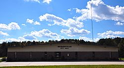
Burnsville City Hall
|
|

Location of Burnsville, Mississippi
|
|
| Country | United States |
| State | Mississippi |
| County | Tishomingo |
| Area | |
| • Total | 4.79 sq mi (12.41 km2) |
| • Land | 4.77 sq mi (12.36 km2) |
| • Water | 0.02 sq mi (0.05 km2) |
| Elevation | 466 ft (142 m) |
| Population
(2020)
|
|
| • Total | 868 |
| • Density | 181.93/sq mi (70.25/km2) |
| Time zone | UTC-6 (Central (CST)) |
| • Summer (DST) | UTC-5 (CDT) |
| ZIP code |
38833
|
| Area code(s) | 662 |
| FIPS code | 28-09820 |
| GNIS feature ID | 2405349 |
Burnsville is a town in Tishomingo County in northeastern Mississippi, United States. The population was 936 at the 2010 census.
Contents
Geography
Burnsville is located on the west side of the Tennessee–Tombigbee Waterway. The town is at the intersection of US Route 72 and Mississippi Highway 365. U.S. 72 runs from west to east through the southern part of the town, leading southeast 8 mi (13 km) to Iuka, the county seat of Tishomingo County, and northwest 14 mi (23 km) to Corinth. MS Highway 365 runs through the main part of town from north to south, leading north 6 mi (9.7 km) to Doskie and south to Bay Springs Lake.
According to the United States Census Bureau, the town has a total area of 4.8 square miles (12 km2), of which 4.8 square miles (12 km2) is land and 0.04 square miles (0.10 km2) (0.42%) is water.
Rivers and streams
- Little Yellow Creek
- Yellow Creek
- Tennessee-Tombigbee Waterway
Other formations
- Turnpike Hill lies just east of the town on the east side of the Tennessee-Tombigbee Waterway.
Demographics
| Historical population | |||
|---|---|---|---|
| Census | Pop. | %± | |
| 1880 | 240 | — | |
| 1890 | 318 | 32.5% | |
| 1900 | 222 | −30.2% | |
| 1910 | 336 | 51.4% | |
| 1920 | 363 | 8.0% | |
| 1930 | 404 | 11.3% | |
| 1940 | 449 | 11.1% | |
| 1950 | 525 | 16.9% | |
| 1960 | 416 | −20.8% | |
| 1970 | 435 | 4.6% | |
| 1980 | 889 | 104.4% | |
| 1990 | 949 | 6.7% | |
| 2000 | 1,034 | 9.0% | |
| 2010 | 936 | −9.5% | |
| 2020 | 868 | −7.3% | |
| U.S. Decennial Census | |||
2020 census
| Race | Num. | Perc. |
|---|---|---|
| White (non-Hispanic) | 803 | 92.51% |
| Black or African American (non-Hispanic) | 4 | 0.46% |
| Native American | 5 | 0.58% |
| Asian | 1 | 0.12% |
| Other/Mixed | 35 | 4.03% |
| Hispanic or Latino | 20 | 2.3% |
As of the 2020 United States census, there were 868 people, 353 households, and 199 families residing in the town.
Education
Public schools
- Burnsville Elementary - grades K-8 with an enrollment of 498 students
Libraries
- Burnsville Public Library - has a collection of ~179,000 books and serial volumes
Transportation
Highways
- U.S. Route 72 - an east–west corridor that runs from Chattanooga, Tennessee to Memphis
- Mississippi Highway 365 - runs north–south through Tishomingo County
Railroads
- Southern Railway System
Media
- WOWL 91.9 FM radio, owned by Southern Community Services, Inc.
Notable person
- Lester Carpenter, member of the Mississippi House of Representatives representing the First District of Mississippi.
See also
 In Spanish: Burnsville (Misisipi) para niños


