Buchanan, Virginia facts for kids
Quick facts for kids
Buchanan, Virginia
|
||
|---|---|---|

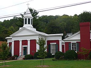
Trinity Episcopal Church in Buchanan, Virginia (1842)
|
||
|
||

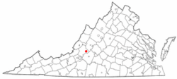
Location of Buchanan, Virginia
|
||
| Country | United States | |
| State | Virginia | |
| County | Botetourt | |
| Area | ||
| • Total | 2.21 sq mi (5.74 km2) | |
| • Land | 2.17 sq mi (5.62 km2) | |
| • Water | 0.05 sq mi (0.12 km2) | |
| Elevation | 850 ft (259 m) | |
| Population
(2020)
|
||
| • Total | 1,196 | |
| • Density | 541.2/sq mi (208.36/km2) | |
| Time zone | UTC-5 (Eastern (EST)) | |
| • Summer (DST) | UTC-4 (EDT) | |
| ZIP Code |
24066
|
|
| Area code(s) | 540 and 826 | |
| FIPS code | 51-10744 | |
| GNIS feature ID | 1492652 | |
Buchanan (/bəˈkænən/ bə-KAN-ən) is a town in Botetourt County, Virginia, United States. The population was 1,196 at the 2020 census. It is part of the Roanoke Metropolitan Statistical Area. It was the western terminus of the James River and Kanawha Canal when construction on the canal ended.
Contents
History
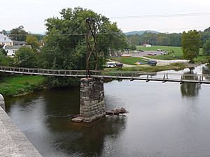
Buchanan was incorporated in 1832. The town of Pattonsburg was founded on the opposite side of the James River (named for Colonel James Patton), and was connected to Buchanan via a bridge. An 1855 gazetteer described Buchanan and Pattonsburg together containing "3 or 4 churches, 1 bank, 1 printing office, and several tobacco factories and mills." Buchanan was named for Virginia colonist John Buchanan (died 1769), a soldier and landowner who built Fort Fauquier on the James River, just south of the town.
The Buchanan Historic District, Buchanan Theatre, Greyledge, Lauderdale, Looney Mill Creek Site, and Wilson Warehouse are listed on the National Register of Historic Places.

Geography
Buchanan is located at 37°31′31″N 79°41′0″W / 37.52528°N 79.68333°W (37.525177, -79.683405).
According to the United States Census Bureau, the town has a total area of 2.2 square miles (5.8 km2), of which 2.2 square miles (5.6 km2) is land and 0.039 square miles (0.1 km2), or 2.09%, is water.
Climate
The climate in this area is characterized by hot, humid summers and generally mild to cool winters. According to the Köppen Climate Classification system, Buchanan has a humid subtropical climate, abbreviated "Cfa" on climate maps.
Demographics
| Historical population | |||
|---|---|---|---|
| Census | Pop. | %± | |
| 1880 | 414 | — | |
| 1890 | 802 | 93.7% | |
| 1900 | 716 | −10.7% | |
| 1910 | 792 | 10.6% | |
| 1920 | 802 | 1.3% | |
| 1930 | 825 | 2.9% | |
| 1940 | 868 | 5.2% | |
| 1950 | 1,300 | 49.8% | |
| 1960 | 1,349 | 3.8% | |
| 1970 | 1,326 | −1.7% | |
| 1980 | 1,205 | −9.1% | |
| 1990 | 1,222 | 1.4% | |
| 2000 | 1,233 | 0.9% | |
| 2010 | 1,178 | −4.5% | |
| 2020 | 1,196 | 1.5% | |
| U.S. Decennial Census | |||
2020 census
As of the census of 2020, there were 1,196 people living in the town. The population density was 540 people per square mile (210/km2). There were 596 housing units. The racial makeup of the town was 91.9% White, 3.1% Black, 0.3% American Indian, 0.3% Asian, 0.0% Pacific Islander, 0.8% Other, and 3.7% from two or more races. Hispanic or Latino of any race were 1.8% of the population.
Education
The town is served by Botetourt County Public Schools. Public school students residing in Buchanan are zoned to attend Buchanan Elementary School, Central Academy Middle School, and James River High School.
The closest higher education institutions are located in Hollins, Lexington, and Roanoke.
Infrastructure
The Town operates its own water and sanitary sewer systems.
Transportation
Airports
The Roanoke-Blacksburg Regional Airport is the closest airport with commercial service to the town.
Roads
U.S. Route 11 runs through the center of town as Main Street. Interstate 81 runs along the northwest side of the town, with access from Exit 167 to the north and Exit 162 to the south, both with Route 11. State Route 43 crosses the James River with Route 11 in the center of town; Route 43 leads northwest up the James River to U.S. Route 220 at Eagle Rock and southeast to the Blue Ridge Parkway and the Peaks of Otter.
Rail
The CSX operated James River Subdivision and Norfolk Southern operated Roanoke District both run through the town. The closest passenger rail service is located in Roanoke.
Notable people
- Mary Johnston, novelist and women's rights activist
- Matthew Ramsey, songwriter and lead singer of country-rock music group Old Dominion
- Hughie Thomasson, musician and member of Outlaws and Lynyrd Skynyrd born in Buchanan
- James Patton, first sheriff of Augusta County, owned a "small stone house" around 1750 at Cherry Tree Bottom, across the James River from Buchanan.
- John Buchanan, who lived for many years in the Anchor and Hope Plantation just west of the town.
See also
 In Spanish: Buchanan (Virginia) para niños


