Buchanan, Georgia facts for kids
Quick facts for kids
Buchanan, Georgia
|
|
|---|---|

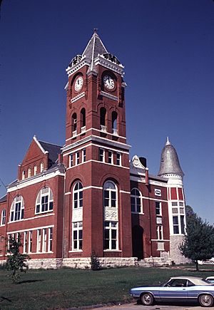
Former Haralson County courthouse in Buchanan, now the Buchanan-Haralson Public Library
|
|

Location in Haralson County and the state of Georgia
|
|
| Country | United States |
| State | Georgia |
| County | Haralson |
| Named for | James Buchanan |
| Area | |
| • Total | 1.70 sq mi (4.40 km2) |
| • Land | 1.49 sq mi (3.86 km2) |
| • Water | 0.21 sq mi (0.54 km2) |
| Elevation | 1,243 ft (379 m) |
| Population
(2020)
|
|
| • Total | 938 |
| • Density | 629.95/sq mi (243.15/km2) |
| Time zone | UTC-5 (Eastern (EST)) |
| • Summer (DST) | UTC-4 (EDT) |
| ZIP code |
30113
|
| Area code(s) | 770 |
| FIPS code | 13-11616 |
| GNIS feature ID | 0354892 |
Buchanan is a city and the county seat of Haralson County, Georgia, United States. The population was 1,104 at the 2010 census, up from 941 at the 2000 census.
Locally, the city's name is pronounced Buck-HAN-uhn.
Contents
History
Buchanan was founded in 1856 as seat of the newly formed Haralson County. It was named for United States President James Buchanan. Buchanan was incorporated as a town in 1857 and as a city in 1902.
It is home of one of few one-room schoolhouses surviving in Georgia, the Little Creek One-room Schoolhouse. The state had about 7,000 of them in 1900.
Geography
Buchanan is located just east of the center of Haralson County at 33°48′6″N 85°11′1″W / 33.80167°N 85.18361°W (33.801726, -85.183506). U.S. Route 27 bypasses the city to the east, leading north 16 miles (26 km) to Cedartown and south 6 miles (10 km) to Bremen.
According to the United States Census Bureau, Buchanan has a total area of 1.7 square miles (4.4 km2), of which 1.5 square miles (3.8 km2) are land and 0.2 square miles (0.5 km2), or 12.42%, are water.
Demographics
| Historical population | |||
|---|---|---|---|
| Census | Pop. | %± | |
| 1880 | 158 | — | |
| 1890 | 324 | 105.1% | |
| 1900 | 359 | 10.8% | |
| 1910 | 462 | 28.7% | |
| 1920 | 491 | 6.3% | |
| 1930 | 429 | −12.6% | |
| 1940 | 504 | 17.5% | |
| 1950 | 651 | 29.2% | |
| 1960 | 753 | 15.7% | |
| 1970 | 800 | 6.2% | |
| 1980 | 1,019 | 27.4% | |
| 1990 | 1,009 | −1.0% | |
| 2000 | 941 | −6.7% | |
| 2010 | 1,104 | 17.3% | |
| 2020 | 938 | −15.0% | |
| U.S. Decennial Census | |||
2020 census
| Race | Num. | Perc. |
|---|---|---|
| White (non-Hispanic) | 802 | 85.5% |
| Black or African American (non-Hispanic) | 71 | 7.57% |
| Asian | 2 | 0.21% |
| Other/Mixed | 44 | 4.69% |
| Hispanic or Latino | 19 | 2.03% |
As of the 2020 United States census, there were 938 people, 436 households, and 274 families residing in the city.
Education
Haralson County School District
The Haralson County School District holds pre-school to grade twelve, and consists of four elementary schools, a middle school, and a high school. The district has 231 full-time teachers and over 3,766 students.
- Buchanan Elementary School
- Buchanan Primary School
- Tallapoosa Primary School
- West Haralson Elementary School
- Haralson County Middle School
- Haralson County High School
See also
 In Spanish: Buchanan (Georgia) para niños

