Brushwood, New South Wales facts for kids
Quick facts for kids BrushwoodNew South Wales |
|
|---|---|

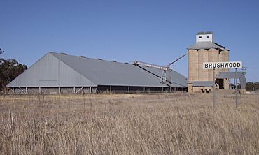
Silos at Brushwood
|
|
| Location |
|
| LGA(s) | Coolamon Shire |
| County | Bourke |
| State electorate(s) | Cootamundra |
| Federal Division(s) | Division of Riverina |
Brushwood is a rural community in the central east part of the Riverina region of New South Wales, Australia. It is situated by road about 6 kilometres (3.7 mi) east of Ganmain and 8 kilometres (5.0 mi) west of Coolamon.
Brushwood lies within the wheat farming belt of the Coolamon Shire Council and is the home of a small railway station (for the uploading of wheat and other grains) and a series of large 30-metre (98 ft) silos.
Black History Month on Kiddle
African-American Ballerinas:
 | Misty Copeland |
 | Raven Wilkinson |
 | Debra Austin |
 | Aesha Ash |

All content from Kiddle encyclopedia articles (including the article images and facts) can be freely used under Attribution-ShareAlike license, unless stated otherwise. Cite this article:
Brushwood, New South Wales Facts for Kids. Kiddle Encyclopedia.

